
Grand Portage National Monument: Difference between revisions
Amwyll Rwden (talk | contribs) m Added distance in rods |
Amwyll Rwden (talk | contribs) m fixed link |
||
| Line 26: | Line 26: | ||
'''Grand Portage National Monument''', a [[U.S. National Monument|United States National Monument]] located on the north shore of [[Lake Superior]] in northeastern [[Minnesota]], preserves a vital center of [[fur trade]] activity and Anishinaabeg [[Ojibwe]] heritage. |
'''Grand Portage National Monument''', a [[U.S. National Monument|United States National Monument]] located on the north shore of [[Lake Superior]] in northeastern [[Minnesota]], preserves a vital center of [[fur trade]] activity and Anishinaabeg [[Ojibwe]] heritage. |
||
The ''Grand Portage'' itself is an {{convert|8.5|mi|km|adj=on}} (2720 [[rod]]) [[portage|footpath]] which bypasses a set of waterfalls and rapids on the last {{convert|20|mi|km}} of the [[Pigeon River (Minnesota-Ontario)|Pigeon River]] before it flows into [[Lake Superior]]. This path is part of the historic [[trade route]] of the [[voyageurs]] between their wintering grounds and their depots to the east. This route, composed of the Pigeon River and other strategic interior [[waterways]] as well as the Grand Portage and many other important land [[portage]]s, was of enormous importance in pre-industrial times, as it provided quick water access from Canada's settled areas and Atlantic ports to the fur rich [[North-Western Territory|NorthWest]]. Some {{convert|50|mi|km}} upstream from Lake Superior, this trade route crosses the [[Height of Land Portage]] connecting South Lake on the Pigeon River watershed with North Lake of the [[Rainy River (Minnesota-Ontario)|Rainy River]] watershed. This portage crosses the [[Northern Divide|Northern]] [[Continental divide]] and therefore provides passage between the [[drainage basin]] of the [[Arctic Ocean]] and that of the [[Great Lakes]] and [[Saint Lawrence River]] to the [[Atlantic Ocean]]. |
The ''Grand Portage'' itself is an {{convert|8.5|mi|km|adj=on}} (2720 [[Rod (length)|rod]]) [[portage|footpath]] which bypasses a set of waterfalls and rapids on the last {{convert|20|mi|km}} of the [[Pigeon River (Minnesota-Ontario)|Pigeon River]] before it flows into [[Lake Superior]]. This path is part of the historic [[trade route]] of the [[voyageurs]] between their wintering grounds and their depots to the east. This route, composed of the Pigeon River and other strategic interior [[waterways]] as well as the Grand Portage and many other important land [[portage]]s, was of enormous importance in pre-industrial times, as it provided quick water access from Canada's settled areas and Atlantic ports to the fur rich [[North-Western Territory|NorthWest]]. Some {{convert|50|mi|km}} upstream from Lake Superior, this trade route crosses the [[Height of Land Portage]] connecting South Lake on the Pigeon River watershed with North Lake of the [[Rainy River (Minnesota-Ontario)|Rainy River]] watershed. This portage crosses the [[Northern Divide|Northern]] [[Continental divide]] and therefore provides passage between the [[drainage basin]] of the [[Arctic Ocean]] and that of the [[Great Lakes]] and [[Saint Lawrence River]] to the [[Atlantic Ocean]]. |
||
==History== |
==History== |
||
Revision as of 13:51, 23 January 2010
Grand Portage National Monument | |
 The Great Hall at Grand Portage | |
 | |
| Nearest city | Grand Portage, Minnesota |
|---|---|
| Area | 710 acres (2.9 km²) |
| Visitation | 68,856 (2007) |
| NRHP reference No. | 66000111[1] |
| Significant dates | |
| Designated HD | October 15, 1966 |
| Designated NMON | January 27, 1960 |
Grand Portage National Monument, a United States National Monument located on the north shore of Lake Superior in northeastern Minnesota, preserves a vital center of fur trade activity and Anishinaabeg Ojibwe heritage.
The Grand Portage itself is an 8.5-mile (13.7 km) (2720 rod) footpath which bypasses a set of waterfalls and rapids on the last 20 miles (32 km) of the Pigeon River before it flows into Lake Superior. This path is part of the historic trade route of the voyageurs between their wintering grounds and their depots to the east. This route, composed of the Pigeon River and other strategic interior waterways as well as the Grand Portage and many other important land portages, was of enormous importance in pre-industrial times, as it provided quick water access from Canada's settled areas and Atlantic ports to the fur rich NorthWest. Some 50 miles (80 km) upstream from Lake Superior, this trade route crosses the Height of Land Portage connecting South Lake on the Pigeon River watershed with North Lake of the Rainy River watershed. This portage crosses the Northern Continental divide and therefore provides passage between the drainage basin of the Arctic Ocean and that of the Great Lakes and Saint Lawrence River to the Atlantic Ocean.
History

As early as 2,000 years ago, Indian Nations probably used Gichi-onigaming, or “the Great Carrying Place”, to travel from summer homes on Lake Superior to winter hunting grounds in the interior of Minnesota and Ontario. In 1729 Cree guide Auchagah drew a map for some of the first French fur traders showing them how to reach the "western sea" of Lake Winnipeg. In time, Grand Portage became the gateway into rich northern fur bearing country connecting remote interior outposts to lucrative international markets.
The Grand Portage trail itself is an 8 1/2 mile trail connecting Grand Portage with Fort Charlotte on the Pigeon River. Voyageurs from the interior of Canada would carry their furs by canoe to Fort Charlotte, and portage the bundles of fur to Grand Portage. There they would meet their counterparts from Montreal, and exchange the furs for trade goods and supplies. Each canoe "brigade" would then return to its starting place.[2]

In mid-July 1802, partners of the most successful fur trade company in North America, the North West Company, met in their Great Hall at Grand Portage, Minnesota and voted to move their summer headquarters from the protected shores of Lake Superior’s Grand Portage Bay 50 miles (80 km) north to the mouth of the Kaministiquia River. Almost from the time the Anglo-Scot Nor’Westers had organized at Grand Portage in the mid 1780s an emerging United States wanted them out. The July vote would mean that 18 buildings constructed from native squared spruce, pine and birch and over 2,000 cedar pickets surrounding them would be torn down, transported north in company schooners and used in constructing the new Fort William far from U.S. soil.
Reopened in 1951 as Grand Portage National Historic Site, it was designated a National Monument in 1958, and the portage trail itself is a Minnesota State Historic Site.[3] The monument's 710 acres (2.9 km2) lie entirely within the boundaries of Grand Portage Ojibwe Indian Reservation. The reconstructed depot celebrates fur trade and Ojibwe lifeways. It was added to the National Register of Historic Places in 1966.
Attractions and events
The portage trail exists in much the same location and condition today, and visitors can hike 8.5 miles (13.7 km) from Lake Superior to the Pigeon River. Volunteers and park staff dress in period attire and explain and interpret what life was like at the turn of the 19th century. Every August, Grand Portage National Monument hosts a rendezvous re-enactment and the Grand Portage Ojibwe Indian Reservation holds a pow wow.
Grand Portage National Monument Heritage Center
Opened in 2007, the Grand Portage National Monument Heritage Center features exhibit galleries about Ojibwe culture and the fur trade, a bookstore, multi-media programs, park offices, archives and a classroom. The center is a collaboration between the National Park Service and the Grand Portage Band, and overlooks the reconstructed fur trading post.
Archeology
Almost all the information known about the physical layout of Grand Portage National Monument comes from archeological studies.[4]
-
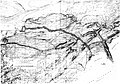 The Route of the Portage
 -
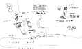 Fort Charlotte, on the Pigeon River


The Route West
John McDonell, a clerk for the Northwest Company, identified the routes between Grand Portage and Rainy Lake in the 1790's. Henry Hind in 1860, traced the route and provided more details that provided by McDonell.[5]
| Name | Length | Distance from Lake Superior |
|---|---|---|
| Grand Portage | 8.16 miles | 8.16 miles |
| Pigeon River | 1.52 | 9.66 |
| Partridge Portage | 0.25 | 9.91 |
| Pigeon River | 4.25 | 14.16 |
| Decharge | 0.25 | 14.41 |
| Pigeon River | 1.75 | 16.16 |
| Décharge | 0.35 | 16.51 |
| Pigeon River | 3.13 | 19.64 |
| Fowl Portage | 1.13 | 20.77 |
| Fowl Lake | 4.55 | 25.32 |
| Moose Portage | 0.41 | 25.73 |
| Moose Lake | 4.25 | 29.98 |
| Great Cherry Portage | 0.48 | 30.46 |
| Lake | 0.25 | 30.71 |
| Mud Portage | 0.15 | 30.86 |
| Lake | 0.30 | 31.16 |
| Lesser Cherry Portage | 0.13 | 31.29 |
| Mountain Lake | 7.81 | 39.10 |
| Watap Portage | 0.30 | 39.40 |
| Watap Lake | 3.70 | 43.10 |
| Great New Portage | 1.46 | 44.56 |
| Rose Lake | 3.0 | 47.56 |
| Portage | 0.01 | 47.57 |
| Mud Lake | 2.62 | 50.19 |
| Portage | 0.21 | 50.40 |
| South Lake | 2.84 | 53.24 |
| Height of Land Portage | 0.26 | 53.50 miles (86.10 km) |
| Gun Flint Lake E. | 2.77 | 56.27 |
| Décharge | 0.01 | 56.28 |
| Gun Flint Lake W. | 8.92 | 65.20 |
| Rpd | 0.01 | 65.21 |
| Lake Strait | 0.25 | 65.46 |
| Little Rock Portage | 0.02 | 65.48 |
| Lake Strait | 0.75 | 66.23 |
| Rapid | 0.01 | 66.24 |
| Lake Strait | 0.25 | 66.49 |
| Mid-Fall Portage | 0.06 | 66.55 |
| Lake Strait | 0.25 | 66.80 |
| Island Portage | 0.29 | 67.09 |
| Lake | 1.35 | 68.44 |
| Rapid | 0.02 | 68.46 |
| Lake | 0.85 | 69.31 |
| Rapid | 0.07 | 69.38 |
| Lake Strait | 0.75 | 70.13 |
| Rapid | 0.05 | 70.18 |
| Lake Strait | 0.50 | 70.68 |
| Rapid | 0.40 | 70.72 |
| Lake Strait | 0.20 | 70.84 [sic] |
| Rapid | 0.01 | 70.85 |
| Lake Strait | 0.45 | 71.05 |
| Rapid | 0.01 | 71.06 |
| Lake Strait | 0.70 | 71.51 [sic] |
| Rapid | 0.02 | 71.53 |
| Lake | 5.35 | 76.88 |
| Décharge | 0.05 | 76.93 |
| Lake Strait | — | 77.63 |
| Portage | 0.01 | 77.64 |
| Lake Seiganagh | 10.07 | 87.71 |
| Portage | 0.01 | 87.72 |
| Swamp Lake | 0.82 | 88.54 |
| Swamp Portage | 0.24 | 88.78 |
| Cypress Lake | 5.35 | 94.13 |
| Portage | 0.02 | 94.15 |
| Knife Lake | 10.70 | 104.85 |
| Portage | 0.04 | 104.89 |
| Lake Strait | 0.20 | 105.09 |
| Portage | 0.09 | 105.18 |
| Lake | 0.60 | 105.78 |
| Carp Portage | 0.15 | 105.93 |
| Birch Lake | 4.0 | 109.03 |
| Portage | 0.11 | 110.04 [sic] |
| Basswood Lake | 16.00 | 126.04 |
| Portage | 0.10 | 126.14 |
| Lake Strait | 0.25 | 126.39 |
| Fir Portage | 0.20 | 126.59 |
| Lake Strait | 0.22 | 126.81 |
| Rapid | 0.04 | 126.85 |
| Lake Strait | 0.35 | 127.20 |
| Rapid | 0.02 | 127.22 |
| Lake Strait | 1.50 | 128.72 |
| Portage | 0.07 | 128.79 |
| Lake | 0.65 | 129.44 |
| Portage | 0.09 | 129.53 |
| Crooked Lake | 16.80 | 146.33 |
| Curtain-Fall Portage | 0.10 | 146.43 |
| Rapid | 0.03 | 146.46 |
| Iron Lake | 4.50 | 150.96 |
| Bottle Portage | 0.25 | 151.21 |
| Nequaquon Lake | 22.10 | 173.31 |
| Portage | 0.02 | 173.43 |
| Lake | 5.60 | 179.03 |
| Portage | 0.15 | 179.18 |
| Lake Strait | 0.50 | 179.68 |
| Portage | 0.04 | 179.72 |
| Loon's Narrows | 7.60 | 187.32 |
| Sand Point Lake | 9.67 | 196.99 |
| Nameukan Lake | 5.20 | 202.19 |
| Nu. Portage | 0.08 | 202.27 |
| Lakelet | 0.25 | 202.52 |
| Portage | 0.14 | 202.66 |
| Lake Strait | 5.20 | 207.86 miles (334.52 km) |
Image gallery
-
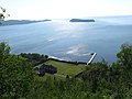 The Grand Portage depot and dock as seen from the top of Mount Rose.
 -
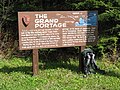 Informational sign located at the midway point of the Grand Portage Trail.
 -
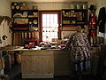 A visiting reenactor in the reconstructed trade shop located in the Great Hall.
 -
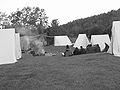 Rendezvous camp at Grand Portage August 2008.
 -
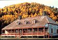 Great Hall in the fall of 1983. Mount Rose rises behind the hall.
 -
 Lake Superior Band of Chippewa Pow Wow at the Grand Portage Indian Reservation in 2009


References
- ^ "National Register Information System". National Register of Historic Places. National Park Service. 2009-03-13.
- ^ Grand Portage National Monument, GORP.
- ^ "Minnesota Statute § 138.57, subd. 5". Minnesota Revisor of Statutes. Retrieved 2007-02-26.
{{cite web}}: Cite has empty unknown parameter:|coauthors=(help) - ^ GRAND PORTAGE: A History of The Sites, People, and Fur Trade; Erwin N. Thompson; U.S. Department of the Interior, National Park Service; Washington, D.C.; June 1969
- ^ GRAND PORTAGE: A History of The Sites, People, and Fur Trade: Erwin N. Thompson; U.S. Department of the Interior, National Park Service: Washington, D.C.; June 1969
See also
- Voyageurs
- Fur trade
- Grand Portage, Minnesota
- Grand Portage Indian Reservation
- Grand Portage State Park, Minnesota
- Isle Royale National Park
- Joseph Bailly
- North West Company
- Pigeon River
- Witch Tree
External links
- National Parks Service - Grand Portage National Monument
- Grand Portage homepage
- Information on the Grand Portage band of Chippewa
- Video documentary on 'Grand Portage during the peak of the Fur Trade'
| Topics | |
|---|---|
| Lists by state |
|
| Lists by insular areas | |
| Lists by associated state | |
| Other areas | |
| Related | |