Smoky Township, Sherman County, Kansas

Smoky Township is one of the thirteen townships of Sherman County, Kansas, United States. The population was 87 at the 2000 census.[1]
Geography[edit]
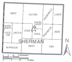
Located in the southern part of the county, it borders the following townships:[2]
- Logan Township — north, west of Itasca Township
- Itasca Township — north, east of Logan Township
- Washington Township — northeastern corner
- Iowa Township — east
- Wallace Township, Wallace County — southeast
- Sharon Springs Township, Wallace County — south
- McPherson Township — west
- Lincoln Township — northwest
It lies south of the county seat of Goodland. There are no communities in the township.[3]
The north fork of the Smoky Hill River flows through Smoky Township. The Sherman Wildlife Area, with areas devoted to hunting and camping, is centered on a lake in the western part of the township, where the river is dammed.[3]
Transportation[edit]
K-27, a north–south highway, is the only significant road in Smoky Township.[3]
Government[edit]
Smoky Township is currently inactive;[4] by Kansas law, when a township becomes inactive, its powers and duties revert to the county government.[5]
References[edit]
- ^ "Subcounty population estimates: Kansas 2000-2007". United States Census Bureau, Population Division. March 18, 2009. Archived from the original (CSV) on March 31, 2009. Retrieved March 23, 2009.
- ^ Detailed Kansas map, United States Census Bureau, 2000. Accessed 2009-03-23.
- ^ a b c DeLorme. Kansas Atlas & Gazetteer. 4th ed. Yarmouth: DeLorme, 2009, p. 28. ISBN 0-89933-342-7.
- ^ U.S. Geological Survey Geographic Names Information System: Smoky Township, Sherman County, Kansas
- ^ §80-120[permanent dead link], Kansas Statutes. Accessed 2009-03-23.

