
23rd Street station (IRT Lexington Avenue Line)
23rd Street | |||||||||||
|---|---|---|---|---|---|---|---|---|---|---|---|
 Uptown platform | |||||||||||
| Station statistics | |||||||||||
| Address | East 23rd Street & Park Avenue South New York, NY 10010 | ||||||||||
| Borough | Manhattan | ||||||||||
| Locale | Gramercy, Flatiron District | ||||||||||
| Coordinates | 40°44′25″N 73°59′11″W / 40.740169°N 73.98644°W | ||||||||||
| Division | A (IRT)[1] | ||||||||||
| Line | IRT Lexington Avenue Line | ||||||||||
| Services | 4 6 | ||||||||||
| Transit | |||||||||||
| Structure | Underground | ||||||||||
| Platforms | 2 side platforms | ||||||||||
| Tracks | 4 | ||||||||||
| Other information | |||||||||||
| Opened | October 27, 1904[2] | ||||||||||
| Accessible | |||||||||||
| Opposite- direction transfer | No | ||||||||||
| Traffic | |||||||||||
| 2023 | 5,409,296[3] | ||||||||||
| Rank | 47 out of 423[3] | ||||||||||
| Station succession | |||||||||||
| Next north | Template:NYCS next | ||||||||||
| Next south | Template:NYCS next Template:NYCS next | ||||||||||
| |||||||||||
| |||||||||||
| |||||||||||


23rd Street is a local station on the IRT Lexington Avenue Line of the New York City Subway. Located at the intersection of Park Avenue South and 23rd Street in Manhattan, it is served by 6 trains at all times, <6> trains during weekdays in the peak direction, and 4 trains during late night hours.
History
Construction started on the first IRT line in 1900.[5] The part of the line from City Hall to just south of 42nd Street was part of the original IRT line, opened on October 27, 1904 including a local station at 23rd Street.[2]
On April 13, 1948, the platform extensions to accommodate ten-car trains at this station along with those at 28th Street, and 33rd Street were opened for use.[6]
In 1981, the MTA listed the station among the 69 most deteriorated stations in the subway system.[7]
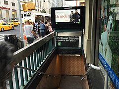
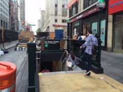
As of late 2014, construction is ongoing to install elevators in the station. To make room for the elevator that will serve the Northbound platform, the Northbound staircase on the northeastern corner of Park Avenue and 23rd Street had to be demolished, and rebuilt/relocated a few feet down the street.[8] The relocated staircase opened in August 2015. The construction is expected to be completed in August 2016.[9]
Station layout
| Ground | Street level | Exit/entrance |
| Platform level | Side platform | |
| Northbound local | ← ← | |
| Northbound express | ← | |
| Southbound express | | |
| Southbound local | | |
| Side platform | ||
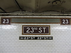
This is a typical local station with four tracks and two side platforms. During station renovations in 1988, the beige tiles were removed and the original white ones restored. It has IND-style signs indicating the way to 22nd and 23rd Streets. An ornate fare control grille on the southbound side is a piece of artwork entitled Long Division by artist Valerie Jaudon, which was installed during the renovation. The station features a back-lit "23rd Street/Park Avenue South" sign at the platform level fare control. There is a low tiled wall at the 22nd Street end which is probably a remnant of a closed crossunder.
The station features modern features such as emergency communication systems, vendors on both south and north bound sides, and Wi-Fi, connecting the communications system with the NYPD Emergency direct line. The station does not contain restrooms.
Exits
| Exit location[10] | Number of exits | Platform served |
|---|---|---|
| 320 Park Avenue South (west side between 23rd and 24th Streets) |
1 | Southbound (open 7am – 7pm, weekdays) |
| NW corner of Park Avenue S and 23rd Street, in the Metropolitan Life Insurance Company Tower | 1 | Southbound |
| SW corner of Park Avenue S and 23rd Street | 2 | Southbound |
| NE corner of Park Avenue S and 23rd Street | 1 | Northbound |
| SE corner of Park Avenue S and 23rd Street | 2 | Northbound |
| NW corner of Park Avenue S and 22nd Street | 1 | Southbound |
| SW corner of Park Avenue S and 22nd Street | 1 | Southbound |
| NE corner of Park Avenue S and 22nd Street | 1 | Northbound |
| SE corner of Park Avenue S and 22nd Street | 1 | Northbound |
Image gallery
-
 Entrance kiosks that used to exist
 -
 Mosaics with name and frieze
 -
 Faience ceiling moldings
 -
 A narrow entrance to the Northbound side
 -
 Relocated Northbound staircase under construction in July 2015
 -
 Relocated Northbound staircase, with construction of the elevator in the background


References
- ^ "Glossary". Second Avenue Subway Supplemental Draft Environmental Impact Statement (SDEIS) (PDF). Vol. 1. Metropolitan Transportation Authority. March 4, 2003. pp. 1–2. Archived from the original (PDF) on February 26, 2021. Retrieved January 1, 2021.
- ^ a b New York Times, Our Subway Open: 150,000 Try It, October 28, 1904
- ^ a b "Annual Subway Ridership (2018–2023)". Metropolitan Transportation Authority. 2023. Retrieved April 20, 2024.
- ^ "Annual Subway Ridership (2018–2023)". Metropolitan Transportation Authority. 2023. Retrieved April 20, 2024.
- ^ "www.nycsubway.org". www.nycsubway.org.
- ^ Report for the three and one-half years ending June 30, 1949. New York City Board of Transportation. 1949.
- ^ Gargan, Edward A. (June 11, 1981). "AGENCY LISTS ITS 69 MOST DETERIORATED SUBWAY STATIONS". The New York Times. Retrieved 13 August 2016.
- ^ http://www.flatirondistrict.nyc/uploaded/files/PDFs/23rd_Street_ADA_Elevator.pdf
- ^ http://web.mta.info/capitaldashboard/allframenew_head.html?PROJNUM=t6041310&PLTYPE=1
- ^ "MTA Neighborhood Maps: Union Square / Gramercy" (PDF). Metropolitan Transportation Authority. 2015. Retrieved August 6, 2015.
External links
- nycsubway.org – IRT East Side Line: 23rd Street
- Station Reporter — 6 Train
- Forgotten NY — Original 28 - NYC's First 28 Subway Stations
- MTA's Arts For Transit — 23rd Street (IRT Lexington Avenue Line)
- 23rd Street entrance from Google Maps Street View
- 22nd Street entrance from Google Maps Street View
- Platforms from Google Maps Street View
| Lexington Ave. Line |
|
|---|---|
| |