2011 Dalbandin earthquake
 | |
| UTC time | 2011-01-18 20:23:23 |
|---|---|
| ISC event | 15938045 |
| USGS-ANSS | ComCat |
| Local date | 18 January 2018 |
| Local time | 01:23:23 PKT |
| Magnitude | 7.2 Mw[1] |
| Depth | 90 km (55.9 mi)[1] |
| Epicenter | 28°45′N 64°03′E / 28.75°N 64.05°E[1] |
| Type | Dip-slip[2] |
| Areas affected | Pakistan |
| Total damage | Moderate[3] |
| Max. intensity | VI (Strong)[2] |
| Casualties | 3 killed, some injured[3] |
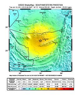
The 2011 Dalbandin earthquake occurred on 19 January at 01:23 AM local time with a moment magnitude of Mw 7.2 and a maximum Mercalli intensity of VI (Strong). The shock occurred in a sparsely populated area of Balochistan, caused moderate damage, three deaths and some injuries.
Earthquake
The tectonic environment of this region is dominated by the motions of the Arabian Plate, the Indian Plate, and the Eurasian Plate. This earthquake occurred as a result of normal faulting within the lithosphere of the subducted Arabian Plate.[2]
Damage
About 200 mud houses, including some government offices, were reported damaged in the Dalbandin area of Pakistan.[4][5][6] Two women died of heart attacks in Quetta after the earthquake, about 330 km northeast of the epicenter, where the Mercalli intensity was IV (Light).[7][8]
Intensity
Tremors after the earthquake reached neighboring countries[4] including Bahrain, UAE, Oman, Iran, Afghanistan, and India. It was felt with a Mercali intensity of IV (Light) in Islamabad, Karachi, Muscat, Delhi, and III (Weak) in Kabul, Dubai, and Abu Dhabi.[2]
See also
References
- ^ a b c ISC (2016), ISC-GEM Global Instrumental Earthquake Catalogue (1900–2012), Version 3.0, International Seismological Centre
- ^ a b c d USGS. "M 7.2 - southwestern Pakistan". United States Geological Survey.
- ^ a b National Geophysical Data Center / World Data Service (NGDC/WDS) (1972), Significant Earthquake Database (Data Set), National Geophysical Data Center, NOAA, doi:10.7289/V5TD9V7K
- ^ a b Martin, S. S.; Kakar, D. M. (1 August 2012). "The 19 January 2011 Mw 7.2 Dalbandin Earthquake, Balochistan". Bulletin of the Seismological Society of America. 102 (4): 1810–1819. Bibcode:2012BuSSA.102.1810M. doi:10.1785/0120110221. ISSN 0037-1106.
- ^ "Homes damaged after Pakistan earthquake". CNN. 18 January 2011. Retrieved 22 January 2011.
- ^ "Leading News Resource of Pakistan". Daily Times. Archived from the original on 25 May 2012. Retrieved 22 January 2011.
- ^ "Un muerto y varios heridos por terremoto en Pakistán" (in Spanish). El Economista. 18 January 2011. Retrieved 22 January 2011.
- ^ Ali, Saeed (12 December 2010). "Major quake rattles Pakistan | World | News". Toronto Sun. Archived from the original on 11 December 2013.
Further reading
- Shafiq-Ur-Rehman; Azeem, Tahir; Abd El-Aal, Abd el-Aziz Khairy; Nasir, Asma (2013), "Parameterization of 18th January 2011 earthquake in Dalbadin Region, Southwest Pakistan", Nriag Journal of Astronomy and Geophysics, 2 (2): 203–211, Bibcode:2013JAsGe...2..203S, doi:10.1016/j.nrjag.2013.06.001
External links
- Major earthquake strikes southwestern Pakistan – CNN
- Dalbandin, Pakistan Earthquake of 18 January 2011, Mw 7.2 – IIEES
- Pakistan: Post-Earthquake Assessment for Town of Dalbandin, Balochistan (28 Jan 2011) – ReliefWeb
- The International Seismological Centre has a bibliography and/or authoritative data for this event.

