Upwaltham
| Upwaltham | |
|---|---|
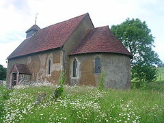
 Church of St. Mary the Virgin | |
Location within West Sussex | |
| Area | 4.94 km2 (1.91 sq mi) [1] |
| Population | 25 [1] 2001 Census |
| • Density | 5/km2 (13/sq mi) |
| OS grid reference | SU942137 |
| • London | 47 miles (76 km) NNE |
| Civil parish |
|
| District | |
| Shire county | |
| Region | |
| Country | England |
| Sovereign state | United Kingdom |
| Post town | PETWORTH |
| Postcode district | GU28 |
| Dialling code | 01798 |
| Police | Sussex |
| Fire | West Sussex |
| Ambulance | South East Coast |
| UK Parliament | |
Upwaltham is a village and parish in the District of Chichester in West Sussex, England located twelve kilometres (8 miles) north east of Chichester on the A285 road. It is in the civil parish of Eartham. This small parish on the South Downs consists of a small early Norman church[2] and adjoining farmstead in an east-west aligned dry valley in the chalk. There are a few more houses at Benges where the A285 to Chichester leaves the valley. From Benges Hill the parish extends south as far as the disused Roman road of Stane Street, in an area of open access woodland. The barns at Upwaltham House Farm have been converted into a conference and wedding venue. The adjoining farmstead of Littleton Farm is only 2 kilometres (1.2 mi) to the east in the same valley, but lies in Duncton parish.
The land area of the parish is 494 hectares (1,221 acres), with a population in the 2001 census of 25 people living in 10 households.[1]
The church
The early Norman church dedicated to St. Mary the Virgin is just over nine hundred years old, and remains little altered in size and structure, although the windows are not original, some being medieval and some Victorian. The three foot (90 cm) thick walls are of stone and downland flint. In Norman style the church has a tall narrow nave and a rounded apse chancel for the altar. The original round Norman chancel arch, between nave and chancel, was replaced after about 100 years by a wider pointed arch. The south door was rebuilt when the church was about 200 years old, and the porch in the nineteenth century. The floor tiling is Victorian. The stone font at the west end of the nave is as old as the church. In the chancel there is a piscina, a small sink for washing communion vessels, which appears to be made from a reused Norman column capital.[3][4]
Parish records of births and deaths from 1592 are held by the West Sussex Record Office.
The ecclesiastical parish is now jointly run with Tillington and Duncton, the Rector living at Tillington.
History
Upwaltham was in the ancient hundred of Boxgrove and listed in the Domesday Book (1086) as having 11 households including one slave; resources included woodland, and land for ploughing and for pigs.[5]
References
- ^ a b c "2001 Census: West Sussex – Population by Parish" (PDF). West Sussex County Council. Archived from the original (PDF) on 8 June 2011. Retrieved 22 May 2009.
- ^ "The Parish Church of St Mary the Virgin, Upwaltham, Church of England". Retrieved 16 June 2019.
- ^ The Corpus of Romanesque Sculpture
- ^ Jeremy Godwin, The Church in the Field, A Guide to the Church 1991 (Available at the church)
- ^ "Open Domesday: (Up)Waltham)". Retrieved 16 June 2019.
External links
![]() Media related to Upwaltham at Wikimedia Commons
Media related to Upwaltham at Wikimedia Commons

