Whitefish Dunes State Park
| Whitefish Dunes State Park | |
|---|---|
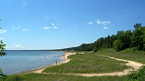
 A Lake Michigan beach in Whitefish Dunes State Park | |
| Location | Door, Wisconsin, United States |
| Coordinates | 44°55′13″N 87°12′16″W / 44.92028°N 87.20444°W |
| Area | 867 acres (351 ha) |
| Established | 1967 |
| Governing body | Wisconsin Department of Natural Resources |
| Website | Whitefish Dunes State Park |
Whitefish Dunes State Park is a 867-acre (351 ha)[2] state park of Wisconsin, United States, on the eastern shore of the Door Peninsula. This day-use park preserves the most substantial sand dunes on the western shore of Lake Michigan. The remains of eight successive prehistoric Native American villages[2] are on the National Register of Historic Places as Whitefish Dunes-Bay View Site. Cave Point County Park is an enclave inside the state park,[3] allowing visitors free foot access to the state park by the shoreline trail connecting the parks.
History
From 100 B.C. to the later 1800s there is evidence of early settlers. The North Bay people occupied the area from 100 B.C. to A.D. 300, leaving pottery in the dunes. Their descendants, the Heins Creek people, then occupied the area. In the Late Woodland period, there were two occupations: a group settling there from A.D. 800-900, and the Oneota, who arrived around A.D. 900. In the early 1800s, fishing camps were established in the area, including one by New Englander James Pearson Clark. Maritime trade began to grow.[2]
Recreation
Recreational activities at Whitefish Dunes include hiking, fishing, canoeing, boating, and swimming. There are several picnic tables located throughout the park and shelters to rent. During the winter there is skiing and snowshoeing.[4]
The Whitefish Dunes Nature Center features exhibits about the ecology, geology and cultural history of the park. The center is open year-round. There are programs offered for children and adults to learn about the park's natural history and cultural history. Naturalists are available to answer questions as well as give tours.[5]
There are several trails within Whitefish Dunes. The Black trail is 2.5 miles (4 km) long through the woods with rock exposure. The Brachipod trail is 1.5 miles (2.4 km) long with fossils and nature views. The Clark Lake Spur trail is .7 miles (1.1 km) long. The Green trail is 1.8 miles (2.9 km) long. There are also the Red, Red Pine, Whitefish Creek Spur, and Yellow trails.[6]
Nature
Mammals that inhabit the park include rabbits, raccoons, skunks, squirrels, and woodchucks. Reptiles and amphibians inhabit the dunes, including frogs, painted turtles, salamanders, and snakes.[7] Whitefish Dunes State Natural Area, a 230-acre (93 ha) area within the state park, protects rare species of plants such as the prairie sand-reed grass and the dune thistle.[8]
Geology
Several fossils were found at the dunes from sediment at the bottom of the water. Fossil sea shells and coral reefs can be seen today at the dunes. The wind and water constantly change and reform the dunes. The wind forces the sand to drop and form a pile, also known as a sand dune. Not many plants make it in the sand dune but the marram grass can survive the winds and water of the dunes.[9]
Climate
| ||||||||||||||||||||||||||||||||||||||||||||||||||||||||||||||||||||||||||||||||||||||||||||||||||||||||||||||||||||||||||||
References
- ^ Protected Planet. "Whitefish Dunes State Park". United Nations Environment World Conservation Monitoring Centre. Retrieved 26 Dec 2018.
- ^ a b c "History". Whitefish Dunes State Park. Wisconsin DNR. July 19, 2013. Retrieved September 4, 2013.
- ^ Cave Point County Park kiosk historical notes and Cave Point County Park description in Door County Outdoors: A Guide to the Best Hiking, Biking, Paddling, Beaches, and Natural Places by Magill Weber, Madison, Wisconsin: University of Wisconsin Press, 2011, page 169
- ^ "Activities and recreation". Whitefish Dunes State Park. Wisconsin DNR. January 18, 2013. Retrieved September 4, 2013.
- ^ "Nature Center". Whitefish Dunes State Park. Wisconsin DNR. July 10, 2013. Retrieved September 4, 2013.
- ^ "Trails". Whitefish Dunes State Park. Wisconsin DNR. July 10, 2013. Retrieved September 4, 2013.
- ^ "Nature". Whitefish Dunes State Park. Wisconsin DNR. May 16, 2012. Retrieved September 4, 2013.
- ^ "Whitefish Dunes State Natural Area". Wisconsin DNR. September 4, 2013. Retrieved September 4, 2013.
- ^ "Geology". Whitefish Dunes State Park. Wisconsin DNR. May 16, 2012. Retrieved September 4, 2013.
- ^ "NASA Earth Observations Data Set Index". NASA. Retrieved 30 January 2016.
External links
- Whitefish Dunes State Park Wisconsin Department of Natural Resources
- IUCN Category III
- Archaeological sites on the National Register of Historic Places in Wisconsin
- Dunes of the United States
- IUCN Category V
- Native American history of Wisconsin
- Nature centers in Wisconsin
- Protected areas established in 1967
- Protected areas of Door County, Wisconsin
- State parks of Wisconsin
- Landforms of Door County, Wisconsin
- National Register of Historic Places in Door County, Wisconsin
- 1967 establishments in Wisconsin


