Kamikawa, Hyōgo
Appearance
Kamikawa
神河町 | |
|---|---|
Town | |
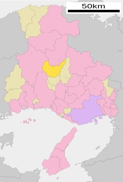
 Location of Kamikawa in Hyōgo Prefecture | |
| Coordinates: 35°4′N 134°44′E / 35.067°N 134.733°E | |
| Country | Japan |
| Region | Kansai |
| Prefecture | Hyōgo Prefecture |
| District | Kanzaki |
| Area | |
• Total | 202.27 km2 (78.10 sq mi) |
| Population (April 30, 2017) | |
• Total | 11,735 |
| • Density | 58/km2 (150/sq mi) |
| Time zone | UTC+09:00 (JST) |
| Website | www |
Kamikawa (神河町, Kamikawa-chō) is a town located in Kanzaki District, Hyōgo Prefecture, Japan.
The town was founded on November 7, 2005 by the merger of Kanzaki and Ōkawachi, both from Kanzaki District.
With data from the year 2017, the town has an estimated population of 11,735.[1] The total area is 202.27 km².
 |
 |
References
- ^ "Official website of Kamikawa Town" (in Japanese). Japan: Kamikawa Town. Retrieved 13 May 2017.
External links
 Media related to Kamikawa, Hyōgo at Wikimedia Commons
- Kamikawa official website (in Japanese)


