Palinyewah
| Palinyewah New South Wales | |
|---|---|
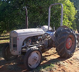
 A Ferguson TE20 tractor, located at a citrus orchard in Palinyewah | |
| Coordinates | 33°50′0″S 142°1′0″E / 33.83333°S 142.01667°E |
| Population | 82 (2016 census) |
| Postcode(s) | 2648 |
| Location | |
| LGA(s) | Wentworth Shire |
| State electorate(s) | Murray |
| Federal division(s) | Farrer |
Palinyewah (also known as Ellerslie) is a locality in New South Wales, Australia, located approximately 47 km north-east of Wentworth, New South Wales. The area is largely devoted to citrus fruit production.
The Palinyewah Public School opened in May, 1954, starting out in a small shed on a nearby farm.[2]
References
- ^ Travelmate
- ^ Palinyewah Public School Archived 2008-07-19 at the Wayback Machine
External links
![]() Media related to Palinyewah at Wikimedia Commons
Media related to Palinyewah at Wikimedia Commons

