Kõinastu
Appearance
From Wikipedia, the free encyclopedia
This is an old revision of this page, as edited by Estopedist1 (talk | contribs) at 11:52, 29 July 2021 (reference + format, replaced: {{short description → {{Short description, {{coord| → {{Coord|, {{reflist}} → {{Reflist}}). The present address (URL) is a permanent link to this revision, which may differ significantly from the current revision.
Revision as of 11:52, 29 July 2021 by Estopedist1 (talk | contribs) (reference + format, replaced: {{short description → {{Short description, {{coord| → {{Coord|, {{reflist}} → {{Reflist}})
Island in Estonia
Place in Saare County, Estonia
Kõinastu | |
|---|---|
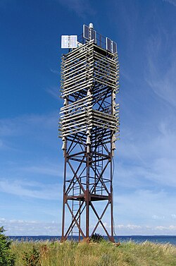
 Kõinastu light beacon | |
| Coordinates: 58°38′07″N 23°00′53″E / 58.63528°N 23.01472°E / 58.63528; 23.01472 | |
| Country | |
| County | |
| Municipality | |
| Area | |
| • Total | 2.62 km2 (1.01 sq mi) |
| Population (01.01.2011[1]) | |
| • Total | 4 |
| • Density | 1.5/km2 (4.0/sq mi) |
Kõinastu is a 2.62 km² islet in the southern part of the Väinameri Sea, Estonia.[2] Administratively it forms Kõinastu village which is part of Saaremaa Parish, Saare County. Kõinastu has a population of 4 (as of 1 January 2011[update]).[1]
References
- ^ a b "Elanikkond" (in Estonian). Orissaare vald. Archived from the original on 16 March 2012. Retrieved 2 April 2011.
- ^ Classification of Estonian administrative units and settlements 2014[dead link] (retrieved 28 July 2021)
| Town | ||
|---|---|---|
| Small boroughs | ||
| Villages |
| |
This Saare County location article is a stub. You can help Wikipedia by expanding it. |
Retrieved from "https://en.wikipedia.org/w/index.php?title=Kõinastu&oldid=1036086082"
Hidden categories:
- Pages using gadget WikiMiniAtlas
- CS1 Estonian-language sources (et)
- All articles with dead external links
- Articles with dead external links from May 2024
- Articles with short description
- Short description matches Wikidata
- Short description is different from Wikidata
- Coordinates on Wikidata
- Articles containing potentially dated statements from January 2011
- All articles containing potentially dated statements
- All stub articles


