Vallis Vale
Appearance
| Site of Special Scientific Interest | |
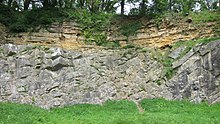
 The De la Beche angular unconformity at Vallis Vale | |
| Location | Somerset |
|---|---|
| Grid reference | ST755490 |
| Coordinates | 51°14′23″N 2°21′08″W / 51.23965°N 2.35234°W |
| Interest | Biological and Geological |
| Area | 23.9 hectares (0.239 km2; 0.092 sq mi) |
| Notification | 1952 |
| Natural England website | |
Vallis Vale (grid reference ST755490) is a 23.9 hectare biological and geological Site of Special Scientific Interest near Great Elm in Somerset, notified in 1952.
Vallis Vale is an ancient woodland site and supports an Ash-Wych Elm stand type with a restricted distribution in Britain.
Vallis Vale exposes some of Britain's most classic rock outcrops, exhibiting several of the most easily demonstrated examples of angular unconformity available. A nationally important research and educational locality, of great renown for the part it has played in the historical development of geological science.
Sources
[edit]- English Nature citation sheet for the site (accessed 10 August 2006)
External links
[edit]- English Nature website (SSSI information)

