Casanare Department
Department of Casanare
Departamento de Casanare | |
|---|---|
|
| |
| Motto(s): Trabajo y Libertad (Spanish: Work and Freedom) | |
| Anthem: Himno de Casanare | |
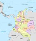
 Casanare shown in red | |
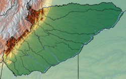
 Topography of the department | |
| Coordinates: 5°21′0″N 72°24′36″W / 5.35000°N 72.41000°W | |
| Country | |
| Region | Orinoquía Region |
| Established | July 4, 1991 |
| Capital | Yopal |
| Government | |
| • Governor | Salomon Andres Sanabria (2020-2023) |
| Area | |
| • Total | 44,640 km2 (17,240 sq mi) |
| • Rank | 10th |
| Elevation | 350 m (1,150 ft) |
| Population (2018)[1] | |
| • Total | 420,504 |
| • Rank | 25th |
| • Density | 9.4/km2 (24/sq mi) |
| Time zone | UTC-05 |
| ISO 3166 code | CO-CAS |
| Municipalities | 19 |
| HDI (2019) | 0.750[2] high · 16th of 33 |
| Website | www.casanare.gov.co |
Casanare (Spanish pronunciation: [kasaˈnaɾe], Spanish: Departamento de Casanare) is a department located in the central eastern of Colombia. It's famous for it's oil and natural gas production as well as it's livestock and extensive plains.[3] It's also the tenth largest department with an area of 44,490 km², similar to that of Denmark, but also the seventh least densely populated.
It's capital is Yopal, which is also the episcopal seat of the Roman Catholic Diocese of Yopal.
It contains oil fields and an 800 km pipeline leading to the coastal port of Coveñas owned by BP.
Rivers and dams
The Upía River (Río Upía) is in Casanare.[4] Casanare, Ariporo, Guachiría, Guanapalo, Pauto, Tocaría, Cravo Sur, Cusiana, Túa y Upía.
History
| Year | Pop. | ±% |
|---|---|---|
| 1973 | - | — |
| 1985 | 147,472 | — |
| 1993 | 211,329 | +43.3% |
| 2005 | 295,353 | +39.8% |
| 2018 | 420,504 | +42.4% |
| Source:[5] | ||
A former subregion of Boyacá, Casanare became separate department in 1973.
Municipalities
- Aguazul
- Chámeza
- Hato Corozal
- La Salina
- Maní
- Monterrey
- Nunchía
- Orocué
- Paz de Ariporo
- Pore
- Recetor
- Sabanalarga
- Sácama
- San Luis de Palenque
- Támara
- Tauramena
- Trinidad
- Villanueva
- Yopal, capital
See also
References
- ^ "DANE". Archived from the original on November 13, 2009. Retrieved February 13, 2013.
- ^ "Sub-national HDI - Area Database - Global Data Lab". hdi.globaldatalab.org. Retrieved 2018-09-13.
- ^ S.A.S, Editorial La República. "Campos petroleros de Casanare, los que más aportaron al aumento de la producción". Diario La República (in Spanish). Retrieved 2023-09-12.
- ^ "Archived copy" (PDF). Archived from the original (PDF) on 2009-03-27. Retrieved 2008-09-16.
{{cite web}}: CS1 maint: archived copy as title (link) - ^ "Reloj de Población". DANE. Departamento Administrativo Nacional de Estadísitica. Retrieved 6 July 2017.
Sources and external links
- (in Spanish) Government of Casanare official website


