Livingston Avenue Historic District
Appearance
Livingston Avenue Historic District | |
 | |
| Location | Area surrounding Livingston Avenue between Hale and Morris Sts New Brunswick, New Jersey |
|---|---|
| Coordinates | 40°29′21″N 74°26′53″W / 40.489167°N 74.448056°W |
| NRHP reference No. | 96000072 |
| NJRHP No. | 3307 |
| Significant dates | |
| Added to NRHP | February 16, 1996[1] |
| Designated NJRHP | December 8, 1995 |
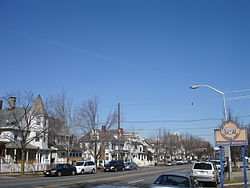
The Livingston Avenue Historic District is a neighborhood of New Brunswick, New Jersey listed in the state and federal registers of historic places.[2][3][4] which includes the Willow Grove Cemetery, the Henry Guest House, and the New Brunswick Free Public Library.
See also
- Civic Square
- National Register of Historic Places listings in Middlesex County, New Jersey
- List of tallest buildings in New Brunswick
- William H. Johnson House
References
- ^ "National Register Information System". National Register of Historic Places. National Park Service. March 13, 2009.
- ^ "New Jersey and National Registers of Historic Places - Middlesex County". New Jersey Department of Environmental Protection - Historic Preservation Office. Retrieved 2015-10-28.
- ^ "Livingston Avenue Historic District". livingplaces.com.
- ^ Regan, Timothy E. (2003), New Brunswick, Arcadia Publishing, ISBN 9780738512860


