Vila Madalena
Appearance
Vila Madalena | |
|---|---|
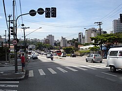
 Rua Heitor Penteado in Vila Madalena | |
| Coordinates: 23°33′09″S 46°41′29″W / 23.5525°S 46.691389°W | |
| Country | |
| Region | Southeast |
| State | |
| Municipality | |
| Administrative Zone | West |
| Subprefecture | Pinheiros |
| District | Pinheiros |
Vila Madalena is an upper middle class neighborhood of the Pinheiros district in the western[1] part of the city of São Paulo, Brazil. The neighborhood is known for its bustling nightlife[2] and its history as a center of São Paulo bohemian culture and art. The neighborhood is filled with dozens of art galleries and studios, an eclectic mix of restaurants and bars and a series of graffiti-covered streets and alleys, and is attracting young professionals.[1]
References
- ^ a b Moreno, Ricardo (February 2014). "Vila Madalena—São Paulo". Monocle magazine.
- ^ "The Economist Magazine Cities Guide: São Paulo". The Economist.
