
Kopar railway station
The article's lead section may need to be rewritten. (February 2019) |


Kopar is a railway station in Kopar Road, Dombivili on the Dahanu Road - Diva - Panvel route of the Central Line, of the Mumbai Suburban Railway network. It is a mini-junction connecting the Central Line and the Dahanu Road- Panvel Line, providing a direct access to the Western Line.
This station is located on 2 levels locally known as Lower Kopar (located on the Central Railway main line) which has an elevation of 7.130 m & Upper Kopar (located on Vasai Road - Panvel Line) which has an elevation of 14.80 m.
Gallery
-
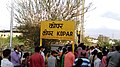 Kopar railway station - Station board
 -
 Kopar railway station - Platformboard
 -
 Upper Kopar railway station - Platform
 -
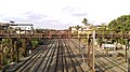 Kopar railway station - View of Central Railway main line from Upper Kopar


This article about a railway station in the Indian state of Maharashtra is a stub. You can help Wikipedia by expanding it. |