Valserhône
Appearance
Valserhône | |
|---|---|
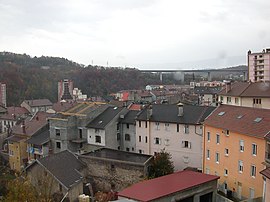
 A general view of Bellegarde-sur-Valserine | |
| Coordinates: 46°06′30″N 5°49′36″E / 46.1083°N 5.8267°E | |
| Country | France |
| Region | Auvergne-Rhône-Alpes |
| Department | Ain |
| Arrondissement | Nantua |
| Canton | Bellegarde-sur-Valserine |
| Intercommunality | Pays Bellegardien |
| Government | |
| • Mayor (2019-2020) | Régis Petit |
| Area 1 | 62.54 km2 (24.15 sq mi) |
| Population (2016) | 16,302 |
| • Density | 260/km2 (680/sq mi) |
| Time zone | UTC+01:00 (CET) |
| • Summer (DST) | UTC+02:00 (CEST) |
| INSEE/Postal code | 01033 /01200 |
| Elevation | 330–1,606 m (1,083–5,269 ft) (avg. 485 m or 1,591 ft) |
| 1 French Land Register data, which excludes lakes, ponds, glaciers > 1 km2 (0.386 sq mi or 247 acres) and river estuaries. | |
Valserhône is a commune in the Ain department in eastern France. It is the result of the merger, on 1 January 2019, of the communes of Bellegarde-sur-Valserine, Châtillon-en-Michaille and Lancrans.[1]
Geography

Valserhône is located at the confluence of the Valserine and the Rhone.
References
- ^ Arrêté préfectoral, 22 October 2018 (in French)
Wikimedia Commons has media related to Valserhône.


