Faeto
Appearance
Faeto | |
|---|---|
| Comune di Faeto | |
 | |
| Coordinates: 41°19′30″N 15°9′39″E / 41.32500°N 15.16083°E | |
| Country | Italy |
| Region | |
| Province | Foggia (FG) |
| Area | |
| • Total | 26.19 km2 (10.11 sq mi) |
| Elevation | 820 m (2,690 ft) |
| Population (31 December 2003)[2] | |
| • Total | 719 |
| • Density | 27/km2 (71/sq mi) |
| Demonym | Faetani |
| Time zone | UTC+1 (CET) |
| • Summer (DST) | UTC+2 (CEST) |
| Postal code | 71020 |
| Dialing code | 0881 |
| ISTAT code | 071023 |
| Patron saint | San Prospero |
| Saint day | Second Sunday in August |
| Website | Official website |
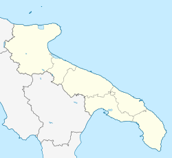
Faeto (Arpitan: Fayéte, IPA: [faˈjet]) is a town and comune in the province of Foggia in the Apulia region of southeast Italy.
It is a mountain village lying astride the Apennines and renowned for its prosciutto, an Italian dry-cured ham known as prosciutto di Faeto. Residents of Faeto and neighbouring Celle di San Vito are speakers of the Franco-Provençal language, otherwise found in an Alpine region spanning northwestern Italy, southeastern France and southwestern Switzerland.
Faeto borders the following municipalities: Biccari, Castelfranco in Miscano, Celle di San Vito, Greci, Orsara di Puglia, Roseto Valfortore.
References
- ^ "Superficie di Comuni Province e Regioni italiane al 9 ottobre 2011". Italian National Institute of Statistics. Retrieved 16 March 2019.
- ^ All demographics and other statistics from the Italian statistical institute (Istat)
External links
Wikimedia Commons has media related to Faeto.


