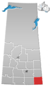
Division No. 1, Saskatchewan
Division No. 1 | |
|---|---|
| Country | |
| Province | |
| Area | |
| • Total | 14,998.19 km2 (5,790.83 sq mi) |
| As of 2016 | |
| Population (2016) | |
| • Total | 31,766 |
| • Density | 2.1/km2 (5.5/sq mi) |
Division No. 1 is one of eighteen census divisions in the province of Saskatchewan, Canada, as defined by Statistics Canada. It is located in the southeast corner of the province, bordering Manitoba and North Dakota. The most populous community in this division is Estevan.
Demographics
In the 2016 Census, Division 1 had a population of 31,766 living in 12,890 of its 15,738 total dwellings, a 1.4% increase from its 2011 population of 31,333. With a land area of 14,998.19 km² (5,790.285 sq mi) it had a population density of 2.1 people per square kilometre in 2016.[1]
Census subdivisions
The following census subdivisions (municipalities or municipal equivalents) are located within Saskatchewan's Division No. 1.
Cities
Towns
Villages
|
|
Rural municipalities
|
Indian reserves
|
|
See also
References
49°08′24″N 103°00′36″W / 49.14000°N 103.01000°W


