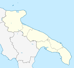
Panni, Apulia
Appearance
Panni | |
|---|---|
| Comune di Panni | |
 | |
| Coordinates: 41°13′N 15°16′E / 41.217°N 15.267°E | |
| Country | Italy |
| Region | |
| Province | Foggia (FG) |
| Area | |
• Total | 32.59 km2 (12.58 sq mi) |
| Elevation | 801 m (2,628 ft) |
| Population (31 December 2003)[2] | |
• Total | 940 |
| • Density | 29/km2 (75/sq mi) |
| Demonym | Pannesi |
| Time zone | UTC+1 (CET) |
| • Summer (DST) | UTC+2 (CEST) |
| Postal code | 71020 |
| Dialing code | 0881 |
| Patron saint | San Costanzo |
| Saint day | 26 August |
| Website | Official website |
Panni (Irpino: Pànne) is a village and comune in the province of Foggia in the Apulia region of southeast Italy.
Geography
Panni stands astride the Daunian Mountains above Cervaro Valley. The neighbouring comuni are Accadia, Bovino, Montaguto (AV), Monteleone di Puglia, Orsara di Puglia and Savignano Irpino (AV).
History
Locally, the name is associated with Pan.
The first mention of Panni is in land registry documents of 1406. In 1494, the short-lived Alfonso II of Naples gave it to Parretto de Ponte and Giovanna de Orenga.[citation needed]
Half the population died in the plague of 1656.[citation needed]
Sister cities
Notes and references
- ^ "Superficie di Comuni Province e Regioni italiane al 9 ottobre 2011". Italian National Institute of Statistics. Retrieved 16 March 2019.
- ^ All demographics and other statistics from the Italian statistical institute (Istat)


