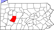
Robinson, Indiana County, Pennsylvania
Appearance
Robinson, Pennsylvania | |
|---|---|
| Coordinates: 40°24′18″N 79°08′18″W / 40.40500°N 79.13833°W | |
| Country | United States |
| State | Pennsylvania |
| County | Indiana |
| Township | West Wheatfield |
| Area | |
• Total | 0.99 sq mi (2.56 km2) |
| • Land | 0.98 sq mi (2.55 km2) |
| • Water | 0.004 sq mi (0.01 km2) |
| Elevation | 1,119 ft (341 m) |
| Population (2010) | |
• Total | 614 |
| • Density | 620/sq mi (240/km2) |
| Time zone | UTC-5 (Eastern (EST)) |
| • Summer (DST) | UTC-4 (EDT) |
| ZIP code | 15949 |
| FIPS code | 42-65360 |
| GNIS feature ID | 2630035 |
Robinson is a census-designated place[1] located in West Wheatfield Township, Indiana County in the state of Pennsylvania. The community is located near the Westmoreland County line and the borough of Bolivar, along Pennsylvania Route 259. As of the 2010 census the population was 614 residents.[2]
References
- ^ https://www.census.gov/2010census/
- ^ "U.S. Census website". United States Census Bureau. Retrieved 2011-05-14.
External links


