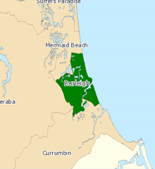
Electoral district of Burleigh
| Burleigh Queensland—Legislative Assembly | |||||||||||||||
|---|---|---|---|---|---|---|---|---|---|---|---|---|---|---|---|
 Electoral map of Burleigh 2017 | |||||||||||||||
| State | Queensland | ||||||||||||||
| MP | Michael Hart | ||||||||||||||
| Party | Liberal National | ||||||||||||||
| Namesake | Burleigh Heads | ||||||||||||||
| Electors | 34,044 (2017) | ||||||||||||||
| Area | 27 km2 (10.4 sq mi) | ||||||||||||||
| Coordinates | 28°5′S 153°26′E / 28.083°S 153.433°E | ||||||||||||||
| |||||||||||||||

Burleigh is an electoral division in the Legislative Assembly of Queensland in Australia.[1]
The division of Burleigh is located on the southern Gold Coast, centred on Burleigh Heads. It also includes parts of the Gold Coast suburbs of Miami, Mermaid Beach, Varsity Lakes and Palm Beach.
Members for Burleigh
| Member | Party | Term | |
|---|---|---|---|
| Judy Gamin | National | 1992–2001 | |
| Christine Smith | Labor | 2001–2012 | |
| Michael Hart | Liberal National | 2012–present | |
Election results
| Party | Candidate | Votes | % | ±% | |
|---|---|---|---|---|---|
| Liberal National | Michael Hart | 13,717 | 49.7 | +3.9 | |
| Labor | Gail Hislop | 9,435 | 34.2 | +3.2 | |
| Greens | Peter Burgoyne | 4,434 | 16.1 | +5.2 | |
| Total formal votes | 27,586 | 94.4 | −2.9 | ||
| Informal votes | 1,625 | 5.6 | +2.9 | ||
| Turnout | 29,211 | 83.9 | −1.8 | ||
| Two-party-preferred result | |||||
| Liberal National | Michael Hart | 15,132 | 54.9 | −0.6 | |
| Labor | Gail Hislop | 12,454 | 45.2 | +0.6 | |
| Liberal National hold | Swing | −0.6 | |||
References
- ^ "Representatives of Queensland State Electorates 1860-2017" (PDF). Queensland Parliamentary Record 2012-2017: The 55th Parliament. Queensland Parliament. Archived from the original (PDF) on 27 April 2020. Retrieved 27 April 2020.
- ^ 2017 State General Election - Burleigh - District Summary, ECQ.
External links
- Electorate Profile (Antony Green, ABC)
