Polnessan
Appearance
Polnessan
| |
|---|---|
 The A713 at Polnessan | |
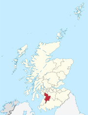
Location within East Ayrshire | |
| Population | 87 |
| OS grid reference | NS 4192 1170 |
| Council area | |
| Lieutenancy area |
|
| Country | Scotland |
| Sovereign state | United Kingdom |
| Post town | AYR |
| Postcode district | KA6 |
| Police | Scotland |
| Fire | Scottish |
| Ambulance | Scottish |
| UK Parliament | |
| Scottish Parliament | |
Polnessan (Scottish Gaelic: Poll an Easain, pool on the small waterfall) is a small rural village in East Ayrshire, Scotland. Polnessan has a population of 87, and is located a mile north of Patna on the A713 road.
Polnessan has no facilities, and is effectively a long row of council housing. The houses were originally built by Ayr County Council for miners and their families on the Houldsworth pit, a nearby coal mine first sunk by Dalmellington Iron Company in 1900.[1]
There are bus services to Ayr and Dalmellington regularly from Polnessan, run by the Stagecoach bus company, as well as postal facilities.
References
- ^ "Polnessan East Ayrshire". Gazetteer for Scotland. Retrieved 30 January 2019.
External links
 Media related to Polnessan at Wikimedia Commons


