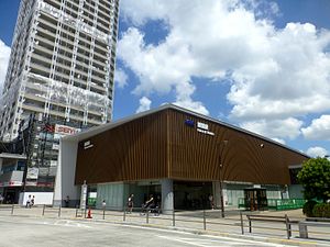
Kokuryō Station
Appearance
Kokuryō Station 国領駅 | |||||
|---|---|---|---|---|---|
 Kokuryō Station in August 2016 | |||||
| General information | |||||
| Location | 3-18 Kokuryō-cho, Chōfu-shi, Tokyo 182-0022 Japan | ||||
| Operated by | |||||
| Line(s) | |||||
| Distance | 14.2 from Shinjuku | ||||
| Platforms | 1 island platform | ||||
| Tracks | 2 | ||||
| Other information | |||||
| Station code | KO16 | ||||
| Website | www | ||||
| History | |||||
| Opened | 15 April 1913 | ||||
| Rebuilt | 2012 | ||||
| Passengers | |||||
| FY2013 | 39,046 (daily) | ||||
| |||||
Kokuryō Station (国領駅, Kokuryō-eki) is a railway station on the Keio Line in Chōfu, Tokyo, Japan, operated by the private railway operator Keio Corporation.[1]
Lines
Sengawa Station is served by the Keio Line, and is located 14.2 kilometers from the starting point of the line at Shinjuku Station.
Station layout
This station consists of one underground island platforms serving two tracks, with the station building located above.[2] The underground tracks opened on August 19, 2012, replacing the ground-level tracks.[3]
Platforms
| 1 | KO Keiō Line | for Chōfu, Keiō Hachiōji KO Keio Takao Line for Takaosanguchi KO Keio Sagamihara Line for Hashimoto |
| 2 | KO Keiō Line | for Meidaimae, Sasazuka, and Shinjuku KO Keio New Line for Shinjuku S Toei Shinjuku Line for Motoyawata |
-
The ticket barriers in July 2015
-
The underground platforms in August 2012 shortly after opening
Adjacent stations
| ← | Service | → | ||
|---|---|---|---|---|
| Keio Line | ||||
| Keiō Liner: Does not stop at this station | ||||
| Special Express: Does not stop at this station | ||||
| Semi Special Express: Does not stop at this station | ||||
| Express: Does not stop at this station | ||||
| Semi Express: Does not stop at this station | ||||
| Rapid: Does not stop at this station | ||||
| Shibasaki | Local | Fuda | ||
History

The station opened on April 15, 1913, and relocated to its present location on December 17, 1927. The station was rebuilt as an underground station in 2012.[3]
Surrounding area
- National Route 20
- Chōfu Post Office
See also
References
- ^ Keio Railway Map
- ^ "Station information by Keio Corporation" (PDF) (in Japanese). Retrieved August 19, 2012.
- ^ a b 京王電鉄2区間が地下線で運転開始 調布駅付近で切り替え工事完了 (in Japanese). MSN Sankei News. August 19, 2012. Archived from the original on 23 August 2012. Retrieved 21 August 2016.
External links
Wikimedia Commons has media related to Kokuryō Station.
- Keio Railway Station Information (in Japanese)
35°39′2.372″N 139°33′29.635″E / 35.65065889°N 139.55823194°E


