Otoyol 30
| O-30 | ||||
|---|---|---|---|---|
| Izmir Beltway İzmir Çevreyolu | ||||
 | ||||
| Route information | ||||
| Part of | ||||
| Length | 51 km (32 mi) | |||
| Existed | 1993–present | |||
| Major junctions | ||||
| South end | ||||
| North end | ||||
| Location | ||||
| Country | Turkey | |||
| Regions | Aegean | |||
| Provinces | Izmir Province | |||
| Major cities | Izmir | |||
| Highway system | ||||
| ||||
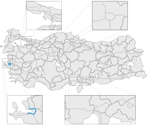
Otoyol 30 (Template:Lang-en), also known as the Izmir Beltway (Turkish: İzmir Çevreyolu) and abbreviated as the O-30, is a 51 km (32 mi) long motorway that runs around the Gulf of Izmir from Balçova to Çiğli.[1] The motorway acts as a bypass for through-traffic around the city and connects to four other motorways; O-5, O-31, O-32 and O-33. For most of its route, the O-30 runs along the perimeter of Izmir, but enters urbanized areas in Balçova, Bornova, Karşıyaka and Çiğli. The entire motorway has six lanes (three in each direction) and is a part of the E87 and E881.
The first section of the O-30 opened to traffic in 1993 with the most recent section opened in 2008.
History
Construction of the O-30 was started in 1988 in order to relive traffic on the congested D-550, which was the only direct north-south road at the time. Along with relieving inner-city congestion, the O-30 was planned to be a connecting hub for two other motorways under construction at the time. The first section of the motorway was opened to traffic on 12 December 1993, between Karabağlar and Işıkkent.[2] This 18 km (11 mi) long section provided an alternate route around the city from Gaziemir (south Izmir) to Bornova (east Izmir) as well as connecting to the O-31, which opened its first section on the same day. Construction of the O-30 slowed down over the next years, due to financial difficulties. Construction of the southern half of the O-30 progressed faster than construction of the northern half. On 10 July 1997, the O-30 was connected to the D-300, which was the main east-west trunk road and on 15 August 1998, the 2.5 km (1.6 mi) long section between Karabağlar and Uzundere was opened to traffic. In 1999, connection to the Izmir Bus Terminal was opened on the 10 April, followed by the 5 km (3.1 mi) long section between Uzundere and Balçova, which was opened on 30 April. The motorway was finally connected to the O-32 on 6 August 2002, via a 1.5 km (0.93 mi) viaduct through Balçova, thus completing the southern half of the O-30.[2] Due to the slow progression of its northern half, the O-30 was nicknamed the motorway that will never open (Turkish: Açılmaz otoyol) and residents of Izmir started to protest the delay.[3] Construction was sped up in 2006 and in January 2007 the 12.6 km (7.8 mi) section between Bornova and Karşıyaka along with two tunnels was opened. Construction progressed at a steady pace over the next years as the O-30 was extended from Karşıyaka to Çiğli on 15 June 2008.
Exit list

| Province | District | km | mi | Exit | Destinations | Notes |
|---|---|---|---|---|---|---|
| İzmir | Balçova | 0.0 | 0.0 | K1 | Trumpet interchange | |
| 1.2 | 0.75 | Fuat Köprülü St. | Northbound entrance, southbound exit | |||
| Karabağlar | 4.6 | 2.9 | K2 | Kütüphaneci Rasime Şeyhoğlu St. | ||
| 6.8 | 4.2 | K3 | Eski İzmir Ave. | |||
| Gaziemir | 7.9 | 4.9 | İzmir Fairground | Nortbound exit, southbound entrance and exit | ||
| 9.4 | 5.8 | K4 | Cloverleaf interchange | |||
| Buca | 10.7 | 6.6 | K4-1 | 677/19 St. | ||
| 16.8 | 10.4 | K5 | Doğuş Ave. | Cloverleaf interchange | ||
| 18.1 | 11.2 | K6 | Dokuz Eylül University | Trumpet interchange | ||
| 19.8 | 12.3 | K7 | Toll motorway | |||
| Bornova | 26.8 | 16.7 | K8 | Aydınlar Ave. | ||
| 27.4 | 17.0 | Kemalpaşa Ave. | Northbound exit | |||
| 29.4 | 18.3 | K9 | Cloverleaf interchange | |||
| 30.7 | 19.1 | K10 | 372nd St. | |||
| 31.7 | 19.7 | K11 | ||||
| 33 | 21 | K12 | Yzb. İbrahim Hakkı Ave. | |||
| 35.3 | 21.9 | K13 | 1620/39th St. | |||
| Bayraklı | 36.4 | 22.6 | Bayraklı-1 Tunnel | |||
| 38.9 | 24.2 | Bayraklı-2 Tunnel | ||||
| 39.9 | 24.8 | K14 | 7375th St. | |||
| Karşıyaka | 41.4 | 25.7 | K15 | Girne Blvd. — Karşıyaka | Cloverleaf interchange | |
| 43.3 | 26.9 | K16 | 6718th St. — Yamaçevler | |||
| 44.5 | 27.7 | K17 | Cloverleaf interchange | |||
| Çiğli | 46.1 | 28.6 | K18 | Caher Dudayev Blvd. — Mavişehir, Çiğli | Via service road | |
| 48.6 | 30.2 | K19 | Mustafa Kemal Atatürk Blvd. — Çiğli O.S.B. | Via service road | ||
| 50.4 | 31.3 | K20 | ||||
1.000 mi = 1.609 km; 1.000 km = 0.621 mi
| ||||||
See also
References
- ^ Tamamlanma Aşamasına Gelen İzmir Çevre Yolu Açılımında Yeni Bir Ulaşım Konsepti
- ^ a b İzmir-Aydın ve İzmir Çevre Yolu İnşaatı, Abdullah Bizden, p. 26
- ^ Izmir Beltway is expanding further


