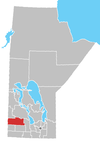
St. Lazare, Manitoba
Appearance
St. Lazare
Ste. Lazare | |
|---|---|
Unincorporated community | |
| Coordinates: 50°26′56″N 101°18′15″W / 50.44889°N 101.30417°W | |
| Country | |
| Province | |
| Region | Westman Region |
| Area | |
| • Total | 2.91 km2 (1.12 sq mi) |
| Elevation | 404 m (1,325 ft) |
| Population (2016) | |
| • Total | 257 |
| • Density | 88/km2 (230/sq mi) |
| Time zone | UTC-6 |
| • Summer (DST) | UTC-5 |
| Postal Code | R0M 1Y0 |
| Area code(s) | Area codes 204 and 431 |
| ISO 3166 code | CA |
St. Lazare is an unincorporated community recognized as a local urban district[2] in the Rural Municipality of Ellice – Archie within the Canadian province of Manitoba that held village status prior to January 1, 2015. The community has a population of 257 inhabitants in the 2016 census.
Local media
Radio
CKSB-2 860 AM first went on the air as a rebroadcast transmitter on March 12, 1969.[3]
External links
- Map of St-Lazare at Statcan
- Former Village of Saint Lazare official website [dead link] Archived version of Village of Ste. Lazare website.
References
- ^ "Elevation of St Lazare". earthtools.org.
- ^ "Local Urban Districts Regulation". Government of Manitoba. April 23, 2016. Retrieved April 24, 2016.
- ^ "Microwave Hook-Up Gives North Live TV". Winnipeg Free Press. April 29, 1969. p. 28.


