Union City station
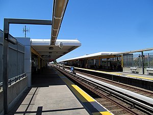
 Union City station platforms in 2017 | |||||||||||||||
| General information | |||||||||||||||
| Location | 10 Union Square, Union City, California | ||||||||||||||
| Coordinates | 37°35′27″N 122°01′02″W / 37.590746°N 122.017282°W | ||||||||||||||
| Owned by | Bay Area Rapid Transit | ||||||||||||||
| Platforms | 2 side platforms | ||||||||||||||
| Connections | |||||||||||||||
| Construction | |||||||||||||||
| Parking | 1197 spaces[1] | ||||||||||||||
| Bicycle facilities | 20 BikeLink lockers | ||||||||||||||
| Accessible | Yes | ||||||||||||||
| History | |||||||||||||||
| Opened | September 11, 1972 | ||||||||||||||
| Rebuilt | February 12, 2014 | ||||||||||||||
| Passengers | |||||||||||||||
| 2024 | 1,816 (weekday average)[2] | ||||||||||||||
| Services | |||||||||||||||
| |||||||||||||||
Union City is a Bay Area Rapid Transit (BART) station serving Union City, California. The station sits near Decoto Road east of Alvarado-Niles Road, directly behind James Logan High School's campus. Local bus service is provided by Union City Transit and AC Transit.
History

Service at the station began on September 11, 1972.[3] The fare lobby features tile mosaics designed by Jean Varda and constructed by Alfonso Pardiñas.[4] Temporary parking spaces were constructed in 2006, and opened in the Summer of 2007. In May 2011, developers, Union City and BART officials unveiled the first residential housing project inside the city/transit agency-specified redevelopment district.[5]
The station underwent construction through 2016 to create a second entrance on the other side of the station. The new eastern station entrance will entail remodeling of the station's platforms and lobby, new bus stop shelters will be built near the entrance, and a pedestrian bridge will be built to connect the East plaza, the opening of this phase will happen at a future date.[6] The BART station building facade has been completely renovated and overhauled facelift which lends it an airy feeling similar to SFO station.
A commuter rail platform for existing Capitol Corridor and proposed Dumbarton Rail Corridor services was proposed in 2008.[7][8][9] However by 2019 the Capitol Corridor was planned to be rerouted over the operationally parallel Union Pacific Coast Line.[10]
See also
References
- ^ "Union City Station". Bay Area Rapid Transit (BART). Retrieved 2013-12-04.
- ^ "Monthly Ridership Reports". San Francisco Bay Area Rapid Transit District. June 2024.
- ^ "BART Chronology January 1947 – March 2009" (PDF). San Francisco Bay Area Rapid Transit District. March 2009. Archived from the original (PDF) on October 13, 2013.
- ^ Weinstein, Dave. "How BART got ART". CA-Modern. Eichler Network. p. 6.
- ^ Maharaj, Zoneil (May 11, 2011). "New Affordable Housing Apartments Ready by October". Union City Patch. Retrieved 2013-12-04.
- ^ Benedetti, Chris (2014-02-21). "Intermodal Station District parking". Contra Costa Times. Retrieved 2014-12-14.
- ^ "Intermodal Station District". City of Union City, California. Archived from the original on 2008-08-27. Retrieved 2008-06-07.
- ^ "BART builds solar-powered rail station". Trains Magazine. 68 (2): 23. February 2008. ISSN 0041-0934.
- ^ "Summary of the Dumbarton Rail Corridor Project Study Report" (PDF). San Mateo County Transit Authority. May 2004. pp. 3, 18. Archived (PDF) from the original on 18 March 2016. Retrieved 18 March 2016.
- ^ "Capitol Corridor Intercity Passenger Rail Service Business Plan Update FY 2020-21 – 2021-22" (PDF). Capitol Corridor Joint Powers Authority. Retrieved 8 June 2020.
External links
![]() Media related to Union City station at Wikimedia Commons
Media related to Union City station at Wikimedia Commons
