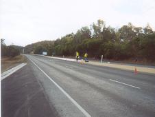
Huon Highway
Appearance
This article needs additional citations for verification. (December 2013) |
Huon Highway | |
|---|---|
 | |
| The Huon Highway at Sandfly | |
 | |
| General information | |
| Type | Highway |
| Length | 116 km (72 mi) |
| Route number(s) | Kingston — Southport |
| Former route number | |
| Major junctions | |
| North end | |
| |
| South end | Kingfish Beach Road Lady Bay Road Southport, Tasmania |
| Location(s) | |
| Major settlements | Sandfly, Grove, Huonville, Franklin, Port Huon, Geeveston, Dover |
| Highway system | |
The Huon Highway is an 87-kilometre (54 mi)[2] highway in southern Tasmania, Australia. The highway forms part of the A6 and connects Hobart with the southern parts of Tasmania. The original Huon Highway (now known as ![]() Huon Road) was a twisty two-lane road skirting around Mount Wellington, but that section of the highway was bypassed in stages when the Southern Outlet was completed in 1968.[2] This provided a more direct, and higher traffic-capacity, route between Hobart and the Huon Valley. A few sections of the old highway remain, all within the Huon Valley, and have been upgraded.
Huon Road) was a twisty two-lane road skirting around Mount Wellington, but that section of the highway was bypassed in stages when the Southern Outlet was completed in 1968.[2] This provided a more direct, and higher traffic-capacity, route between Hobart and the Huon Valley. A few sections of the old highway remain, all within the Huon Valley, and have been upgraded.
See also
References
- ^ Former State Route Numbering System in Tasmania, Ozroads: the Australian Roads Website.
- ^ a b "Road Photos & Information: Tasmania". Expressway - The Australian Highway Site. 2008. Archived from the original on 6 January 2009. Retrieved 5 August 2008.[self-published source]
