Ochtezeele
Appearance
Ochtezeele
Ochtezele | |
|---|---|
 The road into Ochtezeele | |
| Coordinates: 50°49′04″N 2°24′10″E / 50.8178°N 2.4028°E | |
| Country | France |
| Region | Hauts-de-France |
| Department | Nord |
| Arrondissement | Dunkerque |
| Canton | Wormhout |
| Intercommunality | Communauté de communes de Flandre Intérieure |
| Government | |
| • Mayor (2014-2020) | Dominique Deray |
| Area 1 | 5.58 km2 (2.15 sq mi) |
| Population (2021)[1] | 375 |
| • Density | 67/km2 (170/sq mi) |
| Demonym | Ochtezeelois (es) |
| Time zone | UTC+01:00 (CET) |
| • Summer (DST) | UTC+02:00 (CEST) |
| INSEE/Postal code | 59443 /59670 |
| Elevation | 19–62 m (62–203 ft) (avg. 24 m or 79 ft) |
| 1 French Land Register data, which excludes lakes, ponds, glaciers > 1 km2 (0.386 sq mi or 247 acres) and river estuaries. | |
Ochtezeele (from Flemish; Ochtezele in modern Dutch spelling) is a commune in the Nord department in northern France.
The small river Peene Becque flows through the village.
The closest airport to Ochtezeele is Lille Airport (56 km) also worth considering are Le Touquet (Le Touget-Paris-Plage) Airport (64 km), Beauvais-Tillé Airport (153 km), or Paris CDG Airport (201 km).[2]
Heraldry
 |
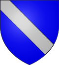
The arms of Ochtezeele are blazoned : Azure, a bend argent. (Bouvignies, Jolimetz and Ochtezeele use the same arms.)
|
See also
References
- ^ "Populations légales 2021" (in French). The National Institute of Statistics and Economic Studies. 28 December 2023.
- ^ ""Information"". Archived from the original on 2009-12-07. Retrieved 2010-07-19.
Wikimedia Commons has media related to Ochtezeele.


