Aceh Singkil Regency
Aceh Singkil Regency
Kabupaten Aceh Singkil | |
|---|---|
 | |
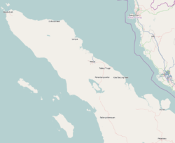
 Location within Aceh | |
| Coordinates: 2°20′N 97°40′E / 2.333°N 97.667°E | |
| Country | Indonesia |
| Region | Sumatra |
| Province | Aceh |
| Established | 1999 |
| Regency seat | Singkil |
| Government | |
| • Regent | Dulmusrid |
| • Vice Regent | Sazali |
| Area | |
• Total | 1,857.88 km2 (717.33 sq mi) |
| Population (mid-2019)[1] | |
• Total | 122,100 |
| • Density | 66/km2 (170/sq mi) |
| Time zone | UTC+7 (IWST) |
| Area code | (+62) 658 |
| Website | acehsingkilkab |
Aceh Singkil Regency is a regency (Template:Lang-id) in the Aceh province of Indonesia. It is situated largely on the island of Sumatra, but also includes the offshore Banyak Islands, the largest of which is Tuangku (Great Banyak), with the principal town of Alaban. The seat of the regency government is at Singkil on the Sumatra coast. It covers an area of 1,857.88 km2, and had a population of 102,509 at the 2010 Census, rising to 114,326 at the 2015 Census; the latest official estimate (as at mid-2019) is 122,100.[2]
Administrative divisions
At the time of the 2010 Census, the regency was divided administratively into ten districts (kecamatan). Subsequent to 2010, the Banjak Islands District was divided into two, with a new Western Banjak Islands District (Kecamatan Pulau Banjak Barat) being carved out of the existing district. The districts are listed below with their areas and populations at the 2010 Census,[3] and the estimated populations in 2017.[4]
| Name | Area in km2 |
Population Census 2010[5] |
Population Estimate 2017[6] |
|---|---|---|---|
| Pulau Banyak (Banyak Islands) |
15.02 | 6,570 | 4,565 |
| Pulau Banyak Barat (Western Banyak Islands) |
278.63 | (a) | 3,094 |
| Singkil | 135.94 | 16,292 | 18,990 |
| Singkil Utara (North Singkil) |
142.23 | 8,918 | 10,395 |
| Kuala Baru | 45.83 | 2,173 | 2,533 |
| Simpang Kanan | 289.96 | 12,716 | 14,822 |
| Gunung Meriah | 224.30 | 30,630 | 35,704 |
| Danau Paris | 206.04 | 6,622 | 7,719 |
| Suro Makmur | 127.60 | 7,559 | 8,811 |
| Singkohor | 159.63 | 5,309 | 6,189 |
| Kota Baharu | 232.69 | 5,720 | 6,667 |
Note:
(a) The 2010 population of Pulau Banyak Barat District is included in the 2010 figure for Pulau Banyak District, from which it was split out.
Tourism - Banyak Islands
Banyak means "many" because there are 99 islands, of which only a few are inhabited. Yachts from Nias Island or directly from abroad carries foreign tourists to Big Palambak Island or Small Palambak Island for fresh water and snorkelling. Tailena Island, Rago-rago Island, Panjang (Long) Island and Matahari (Sun) Island are also suitable for scuba diving, while in Tuwanku (My Master) Island a conservation area for penyu hijau (green sea turtle) and penyu belimbing (leatherback sea turtle) is established.[7]
See also
References
- ^ Badan Pusat Statistik, Jakarta, 2019.
- ^ Badan Pusat Statistik, Jakarta, 2019.
- ^ Biro Pusat Statistik, Jakarta, 2011.
- ^ Badan Pusat Statistik, Jakarta, 2019.
- ^ Biro Pusat Statistik, Jakarta, 2011.
- ^ Badan Pusat Statistik, Jakarta, 2019.
- ^ Yarmen Dinamika (February 2, 2014). "Pulau Banyak Bertabur Pesona".


