
Asswiller
Asswiller | |
|---|---|
 An old house in Asswiller | |
 Coat of arms | |
Location of Asswiller  | |
 Asswiller  Asswiller | |
| Coordinates: 48°52′55″N 7°13′15″E / 48.8819°N 7.2208°E | |
| Country | France |
| Region | Grand Est |
| Department | Bas-Rhin |
| Arrondissement | Saverne |
| Canton | Ingwiller |
| Intercommunality | CC Alsace Bossue |
| Government | |
| • Mayor (2014-2020) | Norbert Stammler |
| Area 1 | 6.02 km2 (2.32 sq mi) |
| Population (2021)[1] | 271 |
| • Density | 45/km2 (120/sq mi) |
| Time zone | UTC+01:00 (CET) |
| • Summer (DST) | UTC+02:00 (CEST) |
| INSEE/Postal code | 67013 /67320 |
| Elevation | 256–337 m (840–1,106 ft) |
| 1 French Land Register data, which excludes lakes, ponds, glaciers > 1 km2 (0.386 sq mi or 247 acres) and river estuaries. | |
Asswiller (German: Aßweiler) is a French commune in the Bas-Rhin department in the Grand Est region of north-eastern France.
The inhabitants of the commune are known as Asswillerois or Asswilleroises.[2]
The commune has been awarded one flower by the National Council of Towns and Villages in Bloom in the Competition of cities and villages in Bloom.[3]
Geography
Asswiller is in the Northern Vosges Regional Natural Park some 27 km south-east of Sarralbe and 38 km south-west of Bitche. Access to the commune is by the D9 road from Durstel in the north-west passing through the heart of the commune and the village and continuing south-east to Petersbach. The D309 road goes south-west from the village to Drulingen. There is a large forest in the west with strips of forest along the borders with the remainder of the commune farmland.[4]
The Isch forms the south-western boundary of the commune as it flows west to eventually join the Sarre west of Wolfskirchen. The Ottwillergraben forms the eastern border of the commune as it flows north to join the Eichel at Tieffenbach.
Neighbouring communes and villages
Places adjacent to Asswiller | ||||||||||||||||
|---|---|---|---|---|---|---|---|---|---|---|---|---|---|---|---|---|
| ||||||||||||||||
Toponymy
- 718: Asco vilare
- 1793: Asveiller
- 1801: Asswiler
In German the commune name is Aßweiler.
History
Asswiller was a small lordship dependent on the Counts of La Petite-Pierre. When the Count palatine of Bavaria, Georg Johann I of Bavaria, took possession of the county, he granted Asswiller as a hereditary fief to the Dalheim family (1588), who were soon succeeded by the Steinkallenfels family: senior officials of the palatine counts. These Protestant lords introduced the Reformation and remained in Asswiller from the 16th century to 1819.[5] In 1789 Asswiller belonged to the Lord of Carbiston who had acquired it in 1771 by marriage with the heiress of the Steincallenfels family.
After the French Revolution Asswiller was attached to France in 1793 by decree of the National Convention which overrode the rights of princes holding possessions.
Heraldry
|
Blazon: Party per fesse, first of Vert a lion passant guardant of Argent, second of Or.
|
Administration

List of Successive Mayors[6]
| From | To | Name | Party | Position |
|---|---|---|---|---|
| 2001 | 2008 | Jean Mathia | UMP | General Councillor |
| 2008 | 2020 | Norbert Stammler |
(Not all data is known)
Demography
In 2010 the commune had 285 inhabitants. The evolution of the number of inhabitants is known from the population censuses conducted in the commune since 1793. From the 21st century, a census of communes with fewer than 10,000 inhabitants is held every five years, unlike larger towns that have a sample survey every year.[Note 1]
Template:Table Population Town


Culture and heritage

Civil heritage
Many buildings and structures in Asswiller are registered as historical monuments:
- A Farmhouse at 2 Rue du Cimetière (1775)
 [7]
[7] - A Chateau at 6 Rue de Drulingen (13th century)[8]
- The Town Hall/School at 10 Rue de Durstel (19th century)[9]
- A Farmhouse at 18 Rue de Durstel (20th century)[10]
- A Courthouse at 2 Rue de Durstel (1733)[11]
- A Farmhouse at 26 Rue de Durstel (1861)[12]
- A Farmhouse at 5 Rue de Durstel (19th century)[13]
- A Farmhouse at 5 Bis Rue de Durstel (1761)[14]
- A Farmhouse at 14 Rue de Petersbach (1803)[15]
- A Farmhouse at 8 Rue de Petersbach (18th century)[16]
- A Mill called Jaegermuhle (1833)[17]
Religious heritage
Several religious buildings and structures are registered as historical monuments:
- A Cemetery at Rue du Cimetière(19th century)[18]
- A Protestant Church at Rue de Durstel (1776)[19]
- A Protestant Presbytery at 4 Rue de Durstel (18th century)[20]
- A Lutheran Church at Rue de l'Eglise (1724)[21]
The Cemetery contains two items that are registered as historical objects:
The Lutheran Church contains two items that are registered as historical objects:
Gallery of Historical Monuments
-
 The Farmhouse at 18 Rue de Durstel
 -
 The old Courthouse at 2 Rue de Durstel
 -
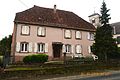
 An old house in Asswiller
 -
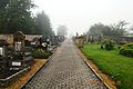 Asswiller Cemetery
 -
 The Rauscher Family Tomb
 -
 The Protestant Church


See also
Notes
- ^ At the beginning of the 21st century, the methods of identification have been modified by Law No. 2002-276 of 27 February 2002 Archived 6 March 2016 at the Wayback Machine, the so-called "law of local democracy" and in particular Title V "census operations" allows, after a transitional period running from 2004 to 2008, the annual publication of the legal population of the different French administrative districts. For communes with a population greater than 10,000 inhabitants, a sample survey is conducted annually, the entire territory of these communes is taken into account at the end of the period of five years. The first "legal population" after 1999 under this new law came into force on 1 January 2009 and was based on the census of 2006.
References
- ^ "Populations légales 2021". The National Institute of Statistics and Economic Studies. 28 December 2023.
- ^ Inhabitants of Bas-Rhin (in French)
- ^ Asswiller in the Competition for Towns and Villages in Bloom Archived June 26, 2015, at the Wayback Machine (in French)
- ^ Google Maps
- ^ Protestants, Durstel, Lutheran parish
- ^ List of Mayors of France (in French)
- ^ Ministry of Culture, Mérimée IA67005492 Farmhouse (in French)
- ^ Ministry of Culture, Mérimée IA67005490 Chateau (in French)
- ^ Ministry of Culture, Mérimée IA67005488 Town Hall/School (in French)
- ^ Ministry of Culture, Mérimée IA67005500 Farmhouse (in French)
- ^ Ministry of Culture, Mérimée IA67005489 Courthouse (in French)
- ^ Ministry of Culture, Mérimée IA67005495 Farmhouse (in French)
- ^ Ministry of Culture, Mérimée IA67005493 Farmhouse (in French)
- ^ Ministry of Culture, Mérimée IA67005494 Farmhouse (in French)
- ^ Ministry of Culture, Mérimée IA67005497 Farmhouse (in French)
- ^ Ministry of Culture, Mérimée IA67005496 Farmhouse (in French)
- ^ Ministry of Culture, Mérimée IA67005499 Mill called Jaegermuhle (in French)
- ^ Ministry of Culture, Mérimée IA67005498 Cemetery (in French)
- ^ Ministry of Culture, Mérimée IA67005487 Protestant Church (in French)
- ^ Ministry of Culture, Mérimée IA67005491 Protestant Presbytery (in French)
- ^ Ministry of Culture, Mérimée IA67005486 Lutheran Church (in French)
- ^ Ministry of Culture, Palissy IM67009318 Rauscher family tomb (in French)
- ^ Ministry of Culture, Palissy IM67009317 3 Sculptures in the Cemetery (in French)
- ^ Ministry of Culture, Palissy IM67009316 Furniture in the Lutheran Church (in French)
- ^ Ministry of Culture, Palissy IM67009315 Organ in the Lutheran Church (in French)
External links
- Asswiller on the old IGN website (in French)
- Asswiller on Lion1906
- Asweiller on the 1750 Cassini Map
| International | |
|---|---|
| National | |