Hurricane Barry (2019)
| Category 1 hurricane (SSHWS/NWS) | |
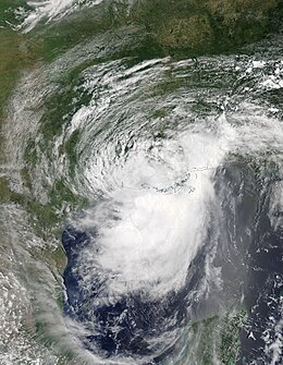
 Hurricane Barry shortly after making landfall in Louisiana on July 13 | |
| Formed | July 11, 2019 |
|---|---|
| Dissipated | July 16, 2019 |
| (Remnant low after July 15) | |
| Highest winds | 1-minute sustained: 75 mph (120 km/h) |
| Lowest pressure | 993 mbar (hPa); 29.32 inHg |
| Fatalities | 1 total |
| Damage | $600 million (2019 USD) |
| Areas affected | Midwestern United States, Southeastern United States, Gulf Coast of the United States, Arkansas, Oklahoma, Great Lakes region, Northeastern United States |
| Part of the 2019 Atlantic hurricane season | |
Hurricane Barry was an asymmetrical Category 1 hurricane that made landfall in Louisiana in July 2019. Barry was the wettest tropical cyclone on record in Arkansas and the fourth-wettest in Louisiana. Barry originated as a mesoscale convective vortex over the Midwest on July 2. The system eventually emerged into the Gulf of Mexico on July 10, whereupon the National Hurricane Center (NHC) designated it as a potential tropical cyclone later. Early on July 11, the system developed into a tropical depression and later into the second named storm of the 2019 Atlantic hurricane season. On July 13, Barry attained maximum 1-minute sustained winds of 75 mph (120 km/h), with a minimum central pressure of 993 millibars (29.3 inHg), becoming the first hurricane of the season. Later that day, Barry made landfall on Marsh Island and second landfall in Intracoastal City, Louisiana, both times as a Category 1 hurricane. Barry subsequently weakened to tropical storm status soon after due to land interaction. The storm continued weakening, and finally degenerated into a remnant low over northern Arkansas on July 15, before dissipating on July 19.
Barry was one of four hurricanes to hit Louisiana at that intensity in the month of July, the others being Bob in 1979, Danny in 1997, and Cindy in 2005.[1] Numerous Tropical Storm watches and warnings were issued ahead of the storm. As Barry was predicted to make landfall as a hurricane, the Tropical Storm warnings were later upgraded into Hurricane warnings. Officials warned of significant impacts from Barry, including high winds, storm surge, and several feet of rain. Hurricane Barry only produced hurricane-force winds in a small area of Louisiana. Its large circulation produced heavy rainfall over a large area, reaching 23.43 in (595 mm) near Ragley, Louisiana, and 16.59 inches (42.1 cm) near Dierks, Arkansas. The latter value was the highest amount of rainfall recorded in Arkansas related to a tropical cyclone. One indirect fatality was attributed to Barry, and the damage was estimated to be about $600 million (2019 USD).
Meteorological history

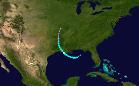
Tropical storm (39–73 mph, 63–118 km/h)
Category 1 (74–95 mph, 119–153 km/h)
Category 2 (96–110 mph, 154–177 km/h)
Category 3 (111–129 mph, 178–208 km/h)
Category 4 (130–156 mph, 209–251 km/h)
Category 5 (≥157 mph, ≥252 km/h)
Unknown
The origins of Barry can be traced to a mesoscale convective vortex that formed over southwestern Kansas on July 2.[2] On July 5, the Climate Prediction Center noted the possibility for this disturbance to interact with a trough of low pressure over the Southeastern United States, eventually triggering a low pressure area over the Gulf of Mexico.[3] The following day, the National Hurricane Center (NHC) highlighted a low likelihood of tropical cyclogenesis while the initial disturbance was still centered well-inland over Tennessee, anticipating that the weather system would track into the northern Gulf of Mexico.[4] Over the next few days, the system drifted southeastward towards Georgia, steered by a ridge to its west.[2] By July 8, the NHC assessed a high probability of a tropical cyclone developing.[5] On July 9, a broad low pressure area exited from the Florida Panhandle into the northeastern Gulf of Mexico, accompanied by scattered thunderstorms. It moved southwestward and curved to the west.[2] On July 10, the NHC initiated advisories on the weather system as Potential Tropical Cyclone Two, due to its threat of producing tropical storm force winds over the United States within a few days. At that time, the low pressure area was experiencing some northerly wind shear, which was expected to decrease. The NHC described the atmospheric conditions, including water temperatures of over 86 °F (30 °C), as "ideal for intensification".[6]

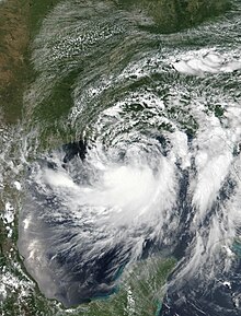
Early on July 11, a tropical depression developed in the northern Gulf of Mexico, about 200 mi (320 km) south of Mobile, Alabama. The depression quickly intensified into Tropical Storm Barry. By that time, the thunderstorms had increased to the south of the circulation.[2] The storm's convection organized into a large rainband south of an elongated circulation,[7] with few thunderstorms near the center.[8] This was due to northerly wind shear and dry air near the center.[2] Despite the asymmetric structure of the storm, Barry gradually intensified.[9] By the morning of July 13, the thunderstorms moved closer to the center of circulation, as upper-level outflow expanded in all directions.[10] The NHC estimated that Barry attained Category 1 hurricane status by 12:00 UTC that day, concluding that Barry was producing a small area of hurricane-force winds. This was based on observations from the Hurricane Hunters, Doppler weather radar wind estimates of 75 mph (121 km/h), and recorded sustained winds of 72 mph (116 km/h) at Eugene Island oil field.[11] Simultaneously, the storm reached its peak intensity, with a minimum central pressure of 993 millibars (29.3 inHg).[2]
At 15:00 UTC that day, Barry made landfall as a Category 1 hurricane on Marsh Island, Louisiana. This made Barry the fourth tropical cyclone recorded making landfall as a hurricane on Louisiana in the month of July. The hurricane quickly weakened to tropical storm status.[1][12][13] Barry progressed farther inland over the next day, weakening into a tropical depression at 21:00 UTC on July 14 over northwestern Louisiana. At that time, the NHC passed on the responsibility for issuing advisories on the storm to the Weather Prediction Center (WPC).[14] At 21:00 UTC on July 15, Barry degenerated into a remnant low over northern Arkansas,[15] which degenerated into a trough a day later over southern Missouri.[2] During the next several days, Barry's remnant moved eastward while gradually weakening, with the WPC issuing their final advisory on the storm at 21:00 UTC on July 17.[16] Early on July 19, Barry's remnant was absorbed into another frontal system off the coast of New Jersey.[17]
Barry was one of four hurricanes to hit Louisiana at that intensity in the month of July, the others being Bob in 1979, Danny in 1997, and Cindy in 2005.[1]
Preparations

On July 10, the NHC began issuing various warnings and watches, including a hurricane watch for the Louisiana coast from Cameron to the Mississippi River Delta, a tropical storm watch from the Mississippi Delta to the mouth of the Pearl River, and a storm surge watch from the mouth of the Pearl River to Morgan City, Louisiana.[18] After the disturbance became Tropical Storm Barry on July 11, the NHC issued a tropical storm warning from the mouth of the Pearl River to Morgan City, and a tropical storm watch eastward to the Mississippi/Alabama border, including the New Orleans metro area, Lake Pontchartrain, and Lake Maurepas. The agency also issued a storm surge warning from the mouth of the Atchafalaya River to Shell Beach, Louisiana.[19]
Due to United States Army Corps of Engineers fears that levees would be overtopped in Plaquemines Parish, Louisiana by storm surge atop elevated streams, a mandatory evacuation was ordered for the parish effective on the morning of July 11. The evacuation order affected approximately 8,000–10,000 residents.[20] An evacuation order was also issued for low-lying areas of Jefferson Parish;[21] the mayor of Grand Isle also issued a mandatory evacuation. Due to the storm threat, the Carnival Valor changed its disembarking point from New Orleans to Mobile, Alabama.[22] Royal Dutch Shell evacuated non-essential personnel from its offshore oil platforms in the Gulf of Mexico.[23] On the afternoon of July 11, the National Hurricane Center issued a hurricane warning for coastal Louisiana between Intracoastal City to Grand Isle, Louisiana.[24] Curfews were enacted in several Louisiana communities across five parishes on July 12.[25] New Orleans mayor LaToya Cantrell urged residents to "shelter in place" but did not order evacuations, citing a Category 3 hurricane as the threshold.[26]
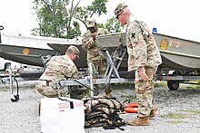
Mississippi governor Phil Bryant declared a state of emergency on July 12, allocating state resources for storm relief and activating the state's emergency operations center.[27] The Mississippi Urban Search and Rescue Task Force dispatched two 12-person water rescue crews to Pike County and Camp Shelby to assist local emergency units.[28]
Impacts

Gulf Coast
Louisiana
While Barry was in its formative stages, it dropped 6 to 9 in (150 to 230 mm) of rainfall across the New Orleans area, causing flooding.[29] An expansive thunderstorm inundated streets and businesses over a six-hour period on the morning of July 10.[30] Portions of the French Quarter were flooded and public transportation was disrupted. The impacts were exacerbated by an elevated Mississippi River amid a prolonged period exceeding flood stage.[31] Officials declared a flash flood emergency in New Orleans, as flooded streets forced businesses and government buildings to close.[32][31]
When Barry made landfall, it produced hurricane-force winds in a small area near the Louisiana coast.[33] The strongest recorded winds on land was 66 mph (106 km/h) at Acadiana Regional Airport in New Iberia. For several days, Barry's intense rainbands affected the same portion of south-central and southwestern Louisiana. The highest rainfall total recorded along Barry's path was 23.43 in (595 mm) near Ragley.[2] Waterspouts were reported on Lake Pontchartrain.[32] One tornado struck the Gentilly neighborhood in New Orleans, damaging two homes.[26] The highest storm surge in Louisiana was 6.13 ft (1.87 m) above normal tide levels at Eugene Island in Atchafalaya Bay. A tide station in Amerada Pass recorded a 6.93 ft (2.11 m) high tide, but the station had been recording higher than normal tides due to high runoff from the Mississippi River. On the southern shore of Lake Pontchartrain, the storm surge reached 4.3 ft (1.3 m).[2] Flooding also occurred on the banks of the Atchafalaya River in Morgan City.[34] The Lower Dularge East Levee in Terrebonne Parish was overtopped, prompting a mandatory evacuation for nearby areas.[35] On the afternoon of July 12, Louisiana Highway 1 south of Golden Meadow—the only thoroughfare leading out of Grand Isle and Port Fourchon—was closed after seawater began to inundate portions of the road.[36]
In a 24-hour span, 28 parishes issued emergency declarations with another 14 finalizing such declarations. After declaring a state of emergency and deploying search and rescue assets,[37] Louisiana Governor John Bel Edwards requested a federal disaster declaration for the entire state on July 11, citing the potential for widespread flooding;[38] the request was granted later that day.[39]
As Barry moved ashore the Louisiana coast on July 13, Entergy and Cleco, the two major electricity companies in southern Louisiana, reported the loss of power to over 114,000 customers. Power lines knocked down by fallen trees in the Metairie area cut power to 5,140 electricity customers in the New Orleans metropolitan area. The most widespread power outages occurred where wind speeds were highest in Lafourche Parish and Terrebonne Parish, as well as eastern Baton Rouge; over 39,000 lost power in these areas.[40] All electricity customers in Grand Isle lost power, and a total of 4,300 customers were affected by power outages as Barry's initial rainbands swept across coastal Louisiana.[41] It also caused The Rolling Stones to postpone their July 14 show at the Superdome to July 15 due to Barry.
Elsewhere

High water levels occurred from the Florida panhandle to the upper Texas coast.[2] Along the Florida panhandle, beaches issued warnings to the public to stay out of the water in order to avoid rip currents and dangerous swimming conditions; however, there were still many calls of swimmers in distress. In Panama City Beach multiple people formed a human chain in an effort to save swimmers who had gotten caught in a rip current caused by the storm. A 67-year-old man drowned in the waters.[42] Five people were rescued 23 mi (37 km) southwest of Gulfport, Mississippi after their ship ran aground.[43]
Barry's large circulation produced gale-force wind gusts along the Gulf Coast as far east Panama City Beach, which recorded gusts of 41 mph (67 km/h). Wind gusts reached 56 mph (91 km/h) at Sabine Pass, Texas.[2] Over land, rainbands brought heavy downpours and occasionally triggered tornado warnings.[44] On July 14, a brief EF0 tornado in Forrest County damaged a few tree limbs on its 0.48 mi (0.77 km) path.[45] In southern Alabama, wind gusts reached 72 mph (116 km/h) on Pinto Island. The outer rainbands of Barry dropped heavy rainfall in southern Alabama, reaching 8.36 in (212 mm) near Fairhope. Heavy rainfall also occurred in southern Mississippi and the Florida panhandle, but was lighter in eastern Teas. The rains flooded roads near the coast, in conjunction with higher tides. Hurricane Barry produced a 3 ft (0.91 m) storm surge in Bay St. Louis, Mississippi, and 2.8 ft (0.85 m) in Bayou La Batre, Alabama. Floodwaters reached several feet deep in some locations, leaving behind 3 ft (0.91 m) of sand on Bienville Boulevard on Dauphin Island. Floodwaters closed lanes of the Cochrane–Africatown USA Bridge in Mobile,[2][46] inundated parts of Beach Boulevard in Pascagoula,[47] and closed roads in the Biloxi area. High winds and saturated soils led to fallen trees.[44] Torrential rainfall overwhelmed sewer systems in Alabama, with over 80,000 gallons (300,000 l) of water spilling into the streets of Mobile County. The storm resulted in the closure of popular beaches, including those in Orange Beach and Gulf Shores.[48]
Following up to 8 inches (20 cm) of rainfall, the National Weather Service issued a rare flash flood emergency (although several others were issued in the path of the storm) at 5 a.m. CDT on July 16, for southern Pike and southern Clark counties, which was soon expanded to include all of Southwestern Arkansas. Clark County Humane Society in Arkadelphia was drenched by flood waters, putting several animals at risk of drowning and hypothermia. A woman was rescued from fast-moving floodwaters in the same area.[49] A rainfall total of 16.59 inches (42.1 cm) was recorded near Dierks, making Barry the wettest tropical cyclone in state history.[50]
More than 60 mm (2.4 in) of rain fell in Toronto on July 17, as the post-tropical cyclone moved just south of the area, resulting in street-level flash flooding and the blockage of a ramp to Ontario Highway 401, where several cars were submerged.[51] Toronto recorded the highest daily rainfall total in the month of July since 2013.[52] The storm also produced a funnel cloud in Oro-Medonte.[51]
See also
- Other storms named Barry
- Tropical Storm Cindy (2017) – a tropical storm that took a similar track to Barry's
- Hurricane Isaac (2012) – a Category 1 hurricane that made landfall in a similar location along the Gulf Coast
- Hurricane Danny (1997) – storm with similar origins that struck the Gulf Coast
- Hurricane Bonnie (1986) — a Category 1 hurricane that also took a similar track to Barry's
- 1943 Surprise Hurricane – the first hurricane to be observed by Hurricane Hunters, taking a similar westward path
- 1940 Louisiana hurricane – produced flooding rainfall over southern Louisiana due to its slow movement
- Hurricane Cindy (2005) - Another Category 1 hurricane that made landfall in Louisiana in the record breaking 2005 Atlantic Hurricane Season.
References
- ^ a b c Mitchell, Chaffin; Navarro, Adriana (July 14, 2019). "First hurricane landfall of the season leaves Louisiana, Mississippi waterlogged". www.accuweather.com. Accuweather. Retrieved July 15, 2019.
- ^ a b c d e f g h i j k l John P. Cangialosi; Andrew B. Hagen; Robbie Berg (November 18, 2019). Hurricane Barry Tropical Cyclone Report (PDF) (Report). National Hurricane Center. Retrieved November 20, 2019.
- ^ Morgan, Leigh (July 5, 2019). "Could Midwest storms help spawn a tropical storm in the Gulf next week?". AL.com. Birmingham, Alabama: Alabama Media Group. Retrieved July 8, 2019.
- ^ Blake, Eric S. (July 6, 2019). "Two-Day Graphical Tropical Weather Outlook". NHC Graphical Outlook Archive. Miami, Florida: National Hurricane Center. Retrieved July 8, 2019.
- ^ Latto, Andrew S.; Pasch, Richard J. (July 8, 2019). "Two-Day Graphical Tropical Weather Outlook". NHC Graphical Outlook Archive. Miami, Florida: National Hurricane Center. Retrieved July 8, 2019.
- ^ Stewart, Stacy R. (July 10, 2019). Potential Tropical Cyclone Two Discussion Number 1 (Report). Miami, Florida: National Hurricane Center. Retrieved July 10, 2019.
- ^ Beven, Beven (July 11, 2019). Tropical Storm Barry Discussion Number 5 (Report). Miami, Florida: National Hurricane Center. Retrieved July 11, 2019.
- ^ Lixion, Avila (July 12, 2019). Tropical Storm Barry Discussion Number 8 (Report). Miami, Florida: National Hurricane Center. Retrieved July 12, 2019.
- ^ Beven, Jack (July 12, 2019). Tropical Storm Barry Discussion Number 9 (Report). Miami, Florida: National Hurricane Center. Retrieved July 12, 2019.
- ^ Daniel P., Brown (July 13, 2019). Tropical Storm Barry Discussion Number 11 (Report). Miami, Florida: National Hurricane Center. Retrieved July 13, 2019.
- ^ Beven, Jack (July 13, 2019). Hurricane Barry Discussion Number 13 (Report). Miami, Florida: National Hurricane Center. Retrieved July 13, 2019.
- ^ Beven, Jack (July 13, 2019). Tropical Storm Barry Discussion Number 13 (Report). Miami, Florida: National Hurricane Center. Retrieved July 14, 2019.
- ^ Beven, Jack (July 13, 2019). Tropical Storm Barry Intermediate Advisory Number 13A (Report). Miami, Florida: National Hurricane Center. Retrieved July 14, 2019.
- ^ Stewart, Stacy R. (July 14, 2019). Tropical Depression Barry Discussion Number 18 (Report). Miami, Florida: National Hurricane Center. Retrieved July 15, 2019.
- ^ Burke, Patrick; Gallina, Gregg (July 15, 2019). Post-Tropical Cyclone Barry Advisory Number 22 (Report). Weather Prediction Center. Retrieved July 15, 2019.
- ^ Brann (July 17, 2019). Post-Tropical Cyclone Barry Advisory Number 30 (Report). Weather Prediction Center. Retrieved July 18, 2019.
- ^ "WPC surface analysis valid for 07/19/2019 at 06 UTC". NOAA's National Weather Service. July 19, 2019. Retrieved July 19, 2019.
- ^ Stewart, Stacy R. (July 10, 2019). Potential Tropical Cyclone Two Public Advisory Number 2 (Report). National Hurricane Center. Retrieved July 10, 2019.
- ^ Beven, Jack (July 11, 2019). Tropical Storm Barry Public Advisory Number 5 (Report). National Hurricane Center. Retrieved July 11, 2019.
- ^ Roberts III, Faimon A. (July 10, 2019). "Mandatory evacuation in Plaquemines: Order to leave East Bank goes into effect Thursday". New Orleans, Louisiana: NOLA.com. Retrieved July 10, 2019.
- ^ Williams, Jessica (July 11, 2019). "Mandatory evacuation for lower-lying areas of Jefferson Parish: 'People's lives are more important'". New Orleans, Louisiana: NOLA.com. Retrieved July 11, 2019.
- ^ "The Latest: Tropical Storm Barry forms in the Gulf". The Minneapolis Star-Tribune. Associated Press. July 11, 2019. Retrieved July 11, 2019.
- ^ Mcauley, Anthony (July 9, 2019). "Shell evacuates non-essential staff from Gulf of Mexico platforms as Invest 92L storm brews". New Orleans, Louisiana: NOLA.com. Retrieved July 10, 2019.
- ^ Beven, Jack (July 11, 2019). Tropical Storm Barry Advisory Number 6 (Report). National Hurricane Center. Retrieved July 11, 2019.
- ^ KATC News (July 12, 2019). "Curfews set for Acadiana". KATC. Acadiana, Louisiana: The E.W. Scripps Co. Retrieved July 12, 2019.
- ^ a b Williams, Jessica (July 11, 2019). "New Orleans officials give updates, warnings on Tropical Storm Barry prep; issue no evacuation orders". New Orleans, Louisiana: NOLA.com. Retrieved July 12, 2019.
- ^ Foxx, Keegan (July 12, 2019). "Mississippi governor declares State of Emergency ahead of Barry". WAPT-TV. Jackson, Mississippi: Hearst Television Inc. Retrieved July 12, 2019.
- ^ Jackson, Ann (July 12, 2019). "State agencies are positioning resources ahead of Tropical Storm Barry's arrival". WLBT. Jackson, Mississippi: WLBT.com. Retrieved July 12, 2019.
- ^ Stewart, Stacy R. (July 10, 2019). Potential Tropical Cyclone Two Intermediate Advisory Number 1A (Report). National Hurricane Center. Retrieved July 10, 2019.
- ^ "New Orleans flooding caused by sudden rain in what might be 'a taste of what could occur'". New Orleans, Louisiana: NOLA.com. July 9, 2019. Retrieved July 10, 2019.
- ^ a b Breslin, Sam (July 10, 2019). "New Orleans Flash Flood Emergency: Streets Inundated, City Offices Closed". The Weather Channel. Atlanta, Georgia: TWC Product and Technology LLC. Retrieved July 10, 2019.
- ^ a b Livingston, Ian (July 10, 2019). "New Orleans just faced a flash flood emergency, and Barry could bring more severe flooding Saturday, testing levees". The Washington Post. Retrieved July 10, 2019. (subscription required)
- ^ Lamers (July 16, 2019). Post-Tropical Cyclone Barry Advisory Number 25 (Report). Weather Prediction Center. Retrieved July 16, 2019.
- ^ "Barry making landfall as hurricane, poised to dump up to 2 feet of rain inland". Archived from the original on July 13, 2019. Retrieved July 19, 2019.
- ^ Sledge, Matt (July 13, 2019). "Overtopped levee in Terrebonne prompts partial evacuation; people, cat rescued from cut off island". New Orleans, Louisiana: NOLA.com. Retrieved July 13, 2019.
- ^ "La. 1 closed south of Golden Meadow". GateHouse Media, LLC. Houma, Louisiana: HoumaToday.com. July 12, 2019. Retrieved July 12, 2019.
- ^ McWhriter, Cameron; Calfas, Jennifer (July 11, 2019). "Tropical Storm Barry Brews, Forcing Evacuations". The Wall Street Journal. New York, New York: Dow Jones & Company, Inc. Retrieved July 11, 2019. (subscription required)
- ^ Edwards, John Bel (July 11, 2019). "Gov. Edwards Request Federal Emergency Declaration in Advance of Tropical Storm Barry" (PDF). Office of the Governor. Letter to Trump, Donald J. Baton Rouge, Louisiana: Office of the Governor of Louisiana. Retrieved July 11, 2019.
- ^ Mumphrey, Nicole (July 12, 2019). "President Trump approves emergency declaration for Louisiana ahead TS Barry". FOX 8. New Orleans, Louisiana: FOX8Live.com. Retrieved July 12, 2019.
- ^ Mcauley, Anthony; Haselle, Della (July 13, 2019). "As Hurricane Barry rolls in, over 114,000 Louisiana customers without power, some areas inaccessible". New Orleans, Louisiana: NOLA.com. Retrieved July 13, 2019.
- ^ Brennan, Sean (July 12, 2019). "Outages: Grand Isle power knocked as storm nears, thousands without power in Jefferson, Terrebonne parishes". WWL-TV. New Orleans, Louisiana: WWL-TV. Retrieved July 12, 2019.
- ^ Adams, Char (July 15, 2019). "Good Samaritans Form Human Chain to Rescue Swimmers from Rip Current in Florida". PEOPLE.com. Retrieved July 18, 2019.
- ^ Beveridge, Lici (July 12, 2019). "Coast Guard aircrew rescues 5 people in Gulf as Tropical Storm Barry gathers steam". Clarion Ledger. Jackson, Mississippi: ClarionLedger.com. Mississippi Clarion Ledger. Retrieved July 12, 2019. (subscription required)
- ^ a b Johnson, Annie (July 13, 2019). "Areas of South Mississippi seeing impacts of Hurricane Barry". www.wlox.com. WLOX. Retrieved July 17, 2019.
- ^ "Tornado Event Report". National Climatic Data Center. 2019. Retrieved November 25, 2019.
- ^ Morgan Barry; Joe Maniscalco (2019). Hurricane Barry - July 13, 2019 (Report). Mobile-Pensacola National Weather Service. Retrieved November 23, 2019.
- ^ "Storm Surge/Tide Event Report". National Climatic Data Center. 2019. Retrieved November 25, 2019.
- ^ Vollers, Anna Claire (July 14, 2019). "Hurricane Barry leaves flooding, sewer overflows, closed beaches in its wake". www.al.com. Alabama Media Group. Retrieved July 17, 2019.
- ^ Brackett, Ron (July 16, 2019). "Barry Impacts: Flooding Swamps Arkansas Police Station and Animal Shelter; Washes Out Highways". weather.com. The Weather Company. Retrieved July 17, 2019.
- ^ "Arkansas 5th state since 2017 to get record tropical rain".
- ^ a b Sonnenbury, Kelly (July 17, 2019). "IN PHOTOS: Funnel clouds, flash flooding, more storms ahead". Pelmorex Media. The Weather Network. Retrieved July 17, 2019.
- ^ Hamilton, Tyler (July 17, 2019). "Toronto just had its rainiest July day in over half a decade". Pelmorex Media. The Weather Network. Retrieved July 17, 2019.
External links
- The National Hurricane Center's advisory archive on Hurricane Barry
- The Weather Prediction Center's advisory archive on Hurricane Berry
- The Weather Prediction Center's storm summaries on Barry

