Domokos
Domokos
Δομοκός | |
|---|---|
Settlement | |
 Domokos | |
| Coordinates: 39°08′N 22°18′E / 39.133°N 22.300°E | |
| Country | Greece |
| Administrative region | Central Greece |
| Regional unit | Phthiotis |
| Area | |
| • Municipal unit | 346.13 km2 (133.64 sq mi) |
| Population (2011)[1] | |
| • Municipal unit | 4,633 |
| • Municipal unit density | 13/km2 (35/sq mi) |
| • Community | 1,531 |
| Time zone | UTC+2 (EET) |
| • Summer (DST) | UTC+3 (EEST) |
| Vehicle registration | ΜΙ |
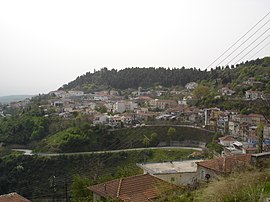
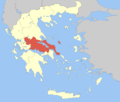
Domokos (Template:Lang-el), the ancient Thaumacus or Thaumace (Θαυμακός, Θαυμάκη),[2] is a town and a municipality in Phthiotis, Greece. The town Domokos is the seat of the municipality of Domokos[3] and of the former Domokos Province. The town is built on a mountain slope overlooking the plain of Thessaly, 38km from the city of Lamia.
History
Ancient
Modern
The area of Domokos became part of Greece in 1881 when the Ottoman Empire ceded Thessaly and a few adjacent areas to Greece. Until 1899, it was part of the Larissa Prefecture.
Battle of Domokos
In 1897, during the Greco-Turkish War, about 2,000 Italian volunteers under the command of Giuseppe Garibaldi's son, Ricciotti Garibaldi, helped the Greeks in the Battle of Domokos. Among them there was also a member of the Italian Parliament, Antonio Fratti, who died in the fighting. The Turkish Army was victorious over the Greek Army.
Transport
The town is served by Domokos railway station on the Piraeus–Platy Mainline, which is located 5 km from the city and serves the surrounding area.
Municipality
The municipality Domokos was formed during the 2011 local government reforms by the merger of the following 3 former municipalities, that became municipal units:[3]
- Domokos
- Thessaliotida
- Xyniada
The municipality has an area of 707.953 km2, the municipal unit 346.129 km2.[4]
Province
The province of Domokos (Template:Lang-el) was one of the provinces of Phthiotis. It had the same territory as the present municipality.[5] It was abolished in 2006.
External links
Municipality of Domokos (in Greek and English)
References
- ^ "Απογραφή Πληθυσμού - Κατοικιών 2011. ΜΟΝΙΜΟΣ Πληθυσμός" (in Greek). Hellenic Statistical Authority.
- ^ Lewis and Short
- ^ a b Kallikratis law Greece Ministry of Interior (in Greek)
- ^ "Population & housing census 2001 (incl. area and average elevation)" (PDF) (in Greek). National Statistical Service of Greece. Archived from the original (PDF) on 2015-09-21.
- ^ "Detailed census results 1991" (PDF). Archived from the original (PDF) on 2016-03-03. (39 MB) (in Greek and French)


