Corfu (regional unit)
Appearance
Corfu
Περιφερειακή ενότητα Κερκύρας | |
|---|---|
 Municipalities of Corfu | |
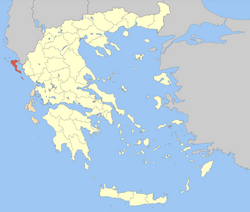
 Corfu within Greece | |
| Coordinates: 39°40′N 19°45′E / 39.667°N 19.750°E | |
| Country | Greece |
| Region | Ionian Islands |
| Capital | Corfu |
| Government | |
| • Vice Governor | Christos Skourtis |
| Area | |
• Total | 641.057 km2 (247.513 sq mi) |
| Population (2011) | |
• Total | 104,371 |
| • Density | 160/km2 (420/sq mi) |
| Time zone | UTC+2 |
| • Summer (DST) | UTC+3 (EEST) |
| Postal codes | 49x xx |
| Area codes | 266x0 |
| ISO 3166 code | GR-22 |
| Car plates | ΚΥ |
| Website | www |
Corfu (Template:Lang-el) is one of the regional units of Greece. It is part of the region of Ionian Islands. The capital of the regional unit is the town of Corfu. The regional unit consists of the islands of Corfu, Paxoi, Othonoi, Ereikoussa, Mathraki and several smaller islands, all in the Ionian Sea.
Administration
The regional unit Corfu is subdivided into 4 municipalities.[1]
- Municipality of Central Corfu and Diapontia Islands
- Municipality of North Corfu
- Municipality of South Corfu
- Municipality of Paxoi
Prefecture
As a part of the 2019 Kallikratis government reform, the regional unit Corfu was created out of the former prefecture Corfu (Template:Lang-el). The prefecture, created in 1864, had the same territory as the present regional unit.
Provinces
The provinces were:
Population
| Year | Population |
|---|---|
| 1991 | 105,043 |
| 2001 | 111,975 |
| 2011 | 104,371 |
See also
References
- ^ "Δήμοι. Σύσταση δήμων. ΝΟΜΟΣ ΚΕΡΚΥΡΑΣ -". 21 March 2019.
- ^ "Archived copy" (PDF). Archived from the original (PDF) on 2012-03-25. Retrieved 2012-10-07.
{{cite web}}: CS1 maint: archived copy as title (link)

