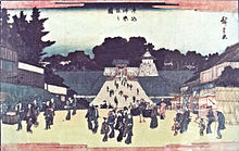
View of Kagurazaka and Ushigome bridge to Edo Castle (牛込神楽坂の図) by Utagawa Hiroshige , 1840. Ushigome (牛込 is the name of a neighborhood in Shinjuku, Tokyo , and a former ward (牛込区 Ushigome-ku ) in the now-defunct Tokyo City . In 1947, when the 35 wards of Tokyo were reorganized into 23, it was merged with Yotsuya ward of Tokyo City and Yodobashi suburban ward of Tokyo-fu to form the modern Shinjuku ward.
Places named after Ushigome
Districts
Yotsuya AreaUshigome Area
Ageba-chō
Akagimotomachi
Akagimotomachi
Babashitamachi
Bentenchō
Enokimachi
Fukuromachi
Haraikata-chō
Haramachi
Higashienokichō
Higashigoken-chō
Ichigayachōenjimachi
Ichigayadai-chō
Ichigayafunagawaramachi
Ichigayahachiman-chō
Ichigayahonmura-chō
Ichigayakaga-chō
Ichigayakōrachō
Ichigayanakano-chō
Ichigayasadohara-chō
Ichigayasanai-chō
Ichigayata-chō
Ichigayatakajōmachi
Ichigayayakuouji-chō
Ichigayayamabushichō
Ichigayayanagi-chō
Iwato-chō
Kaguragashi
Kagurazaka
Kaitaichō
Kikui-chō
Kitamachi
Kitayamabushichō
Kōdachō
Minamienokichō
Minamimachi
Minamiyamabushi-chō
Nakamachi
Nakazatochō
Nandochō
Nijūkimachi
Nishigoken-chō
Nishiwaseda*
Saikuchō
Shimomiyabi-chō
Shinogawamachi
Shiroganechō
Suidōmachi
Sumiyoshimachi
Tansumachi
Tenjinmachi
Tomihisamachi
Toyama * Tsukiji-chō
Tsukudo-chō
Tsukudohachimanchō
Wakamatsumachi
Wakamiyachō
Waseda-chō
Wasedaminamimachi
Wasedatsurumaki-chō
Yamabuki-chō
Yaraimachi
Yochō-chō*
Yokoteramachi Yodobashi Area
Kamiochiai
Kitashinjuku
Nakai
Nakaochiai
Ōkubo
Shimoochiai
Takadanobaba
Totsuka-chō
Nishiochiai
Nishishinjuku
Hyakuninmachi
Kabukichō*
Shinjuku*
Toyama * Nishiwaseda*
Yochō-chō*
Education Major stations
Iidabashi (JR, Metro, Toei)Seibu-Shinjuku (Seibu)Shinjuku (JR, Metro, Toei, Keio, Odakyu, bus terminal)Shinjuku-sanchome (Metro, Toei)Takadanobaba (JR, Metro, Seibu)Yotsuya (JR, Metro) Landmarks * - partially
35°42′06.59″N 139°44′10.08″E / 35.7018306°N 139.7361333°E / 35.7018306; 139.7361333


