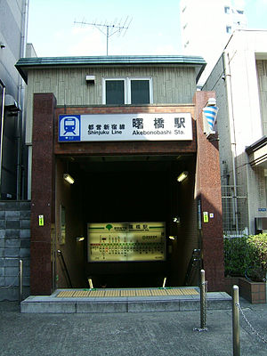
Akebonobashi Station
Akebonobashi Station 曙橋駅 | |
|---|---|
 Entrance to Akebonobashi Station, March 2008 | |
| General information | |
| Location | 7-1 Sumiyoshi-chō, Shinjuku, Tokyo (東京都新宿区住吉町7-1) Japan |
| Operated by | Tokyo Metropolitan Bureau of Transportation (Toei) |
| Line(s) | Toei Shinjuku Line |
| Connections |
|
| Other information | |
| Station code | S-03 |
| History | |
| Opened | 1980 |
| Passengers | |
| [1] | 36,738 daily |
Akebonobashi Station (曙橋駅, Akebonobashi-eki) is a subway station on the Toei Shinjuku Line in Shinjuku, Tokyo, Japan, operated by Toei Subway. Its station number is S-03.
Lines
Akebonobashi Station is served by the Toei Shinjuku Line.
Platforms
Akebonobashi Station consists of two side platforms. Platform 1 is for trains for Shinjuku, Sasazuka and Kanagawa and Platform 2 for trains for Bakuro-yokoyama and Moto-yawata.
History
The station opened on March 16, 1980.
Surrounding area

The station lies beneath Akebonobashi, a bridge at the intersection of Tokyo Metropolitan Route 319 (Gaien-Higashi-dōri) and Metropolitan Route 302 (Yasukuni-dōri). The former headquarters of Fuji Television were located nearby, but have since been redeveloped into a high-rise apartment complex named Kawadacho Confo Garden. Other points of interest include:
- Ministry of Defense
- Chuo University, Ichigaya Campus
- Tokyo Women's Medical University and Hospital
- Akebonobashi-dōri shopping street (The former name was Fuji Television street)
- Yotsuya-sanchōme Station (Tokyo Metro Marunouchi Line) (8 minutes walk south)
- Ushigome-Yanagichō Station (Toei Ōedo Line) (10 minutes walk north)
Connecting bus services
Stop: Akebonobashi
- Shiro 61 for Shinjuku Station (west exit), Nerima Garage
Stop: Arakichō
- Sō 81 for Sōdai-seimon (Waseda University), Shibuya Station (east exit)
Stop: Kappazaka-shita
- Taka 71 for Kudanshita Station, Takadanobaba Station (via Ōkubo-dōri)
- Shuku 75 for Shinjuku Station (west exit), Miyakezaka (via Tokyo Women's Medical University)
Adjacent stations
| « | Service | » | ||
|---|---|---|---|---|
| Express: Does not stop at this station | ||||
| Toei Shinjuku Line (S-03) | ||||
| Shinjuku-sanchōme (S-02) | Local | Ichigaya (S-04) | ||
References
- ^ "Akebonobashi Station information" (in Japanese). Tokyo Metropolitan Bureau of Transportation. Retrieved October 2009.
{{cite web}}: Check date values in:|accessdate=(help)
