
Argis
Argis | |
|---|---|
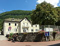
 Argis Town Hall | |
.svg) Coat of arms | |
Location of Argis  | |
 Argis  Argis | |
| Coordinates: 45°56′05″N 5°29′30″E / 45.9347°N 5.4917°E | |
| Country | France |
| Region | Auvergne-Rhône-Alpes |
| Department | Ain |
| Arrondissement | Belley |
| Canton | Ambérieu-en-Bugey |
| Intercommunality | CC Plaine Ain |
| Government | |
| • Mayor (2014-2020) | Marcel Chevé |
| Area 1 | 7.84 km2 (3.03 sq mi) |
| Population (2015) | 433 |
| • Density | 55/km2 (140/sq mi) |
| Time zone | UTC+01:00 (CET) |
| • Summer (DST) | UTC+02:00 (CEST) |
| INSEE/Postal code | 01017 /01230 |
| Elevation | 300–819 m (984–2,687 ft) (avg. 320 m or 1,050 ft) |
| 1 French Land Register data, which excludes lakes, ponds, glaciers > 1 km2 (0.386 sq mi or 247 acres) and river estuaries. | |
Argis is a French commune in the Ain department in the Auvergne-Rhône-Alpes region of eastern France.
The inhabitants of the commune are known as Argissiens or Argissiennes[1]
Geography

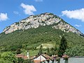
Argis is in the mountains of the southern Jura in the mountains of Bugey in the valley of the Albarine between Tenay and Saint-Rambert-en-Bugey. Altitude varies from 315 metres in the valley to 800 metres on the slopes of the valley.
The commune is some 10 km east of Amberieu-en-Bugey and 10 km south-west of Hauteville-Lompnes. It can be accessed on the D1504 road from Saint-Rambert-en-Bugey in the north-west passing through the northern border of the commune then south to the village and continuing south to Tenay. The D104 road also goes from the village over a tortuous mountain route to Arandas in the south-west. There are also many small mountain roads in the commune. The railway line from Saint-Rambert-en-Bugey to Tenay also passes through the commune parallel to the D1504 road. There is no station in the commune with the nearest station being the one near Tenay. In addition to the village there is the small hamlet of Plomb in the south. The commune is mountainous and heavily forested.[2]

The Albarine river passes through the commune from south to north parallel with the railway and the D1504 continuing west to join the Ain near Chez le Bret. A number of streams flow into the river including the Ruisseau de la Gorge, the Ruisseau de la Tine, the Biez Molet, the Biez Michel, and the Biez Gallet.[2]
Neighbouring communes and villages[2] | ||||||||||||||||
|---|---|---|---|---|---|---|---|---|---|---|---|---|---|---|---|---|
| ||||||||||||||||
History
There was a lordship and a castle in the Middle Ages.
Toponymy
Over the centuries, Argis has been called:[3]
- Argil (1242)
- De Argillo (1385)
- Argit (1650)
- Argy (1734)
Heraldry
|
The status of the official emblem has yet to be determined.
Blazon:
|
Administration
List of mayors of Argis[5]
| From | To | Name | Party | Position |
|---|---|---|---|---|
| 1944 | 1959 | Louis Dillenschneider | ||
| 1959 | 1974 | Louis Ronchall | ||
| 1974 | 1974 | Jean Reverdy | ||
| 1974 | 1999 (resigned) | André Ollier | ||
| 1999 | 2001 | Jean-Claude Marquis | ||
| 2001 | 2020 | Marcel Chevé |
(Not all data is known)
Demography
In 2009 the commune had 421 inhabitants. The evolution of the number of inhabitants is known through the population censuses conducted in the commune since 1793. From the 21st century, a census of municipalities with fewer than 10,000 inhabitants is held every five years, unlike larger towns that have a sample survey every year.[Note 1]
Template:Table Population Town

Sites and monuments
- A Waterfall at Côte
- A Urinal
Photo gallery
-
 The School
 -
 The old Post Office
 -
 The old cobbler's shop
 -
 View of Argis and the church
 -
 View of Argis
 -
 Argis in 1860
 -
 An oven in Argis in the 19th century
 -
 The gypsy blacksmith's house in 1860


Notable people linked to the commune
- Antoine-Gaspard Boucher d'Argis was born in the commune on 3 April 1708.
See also
External links
- Argis on Lion1906
- Argis on Google Maps
- Argis on Géoportail, National Geographic Institute (IGN) website Template:Fr icon
- Argil on the 1750 Cassini Map
- Argis on the INSEE website Template:Fr icon
- INSEE Template:Fr icon
Notes and references
Notes
- ^ At the beginning of the 21st century, the methods of identification have been modified by law No. 2002-276 of 27 February 2002 [1] Archived 2016-03-06 at the Wayback Machine, the so-called "law of local democracy" and in particular Title V "census operations" which allow, after a transitional period running from 2004 to 2008, the annual publication of the legal population of the different French administrative districts. For municipalities with a population greater than 10,000 inhabitants, a sample survey is conducted annually, the entire territory of these municipalities is taken into account at the end of the period of five years. The first "legal population" after 1999 under this new law came into force on 1 January 2009 and was based on the census of 2006.
References
- ^ Inhabitants of Ain Template:Fr icon
- ^ a b c Google Maps
- ^ Regional Terms and placenames of French Switzerland and surroundings Template:Fr icon.
- ^ See in French: Argis Archived 2016-03-04 at the Wayback Machine on OLDJP - the Blazon Bank Archived 2013-07-10 at the Wayback Machine
- ^ List of Mayors of France Template:Fr icon