
Armix
Armix | |
|---|---|
 | |
Location of Armix  | |
 Armix  Armix | |
| Coordinates: 45°51′00″N 5°35′11″E / 45.85°N 5.5864°E | |
| Country | France |
| Region | Auvergne-Rhône-Alpes |
| Department | Ain |
| Arrondissement | Belley |
| Canton | Hauteville-Lompnes |
| Intercommunality | CC Bugey Sud |
| Government | |
| • Mayor (2014-2020) | Véronique Vuilloud |
| Area 1 | 6.82 km2 (2.63 sq mi) |
| Population (2015) | 24 |
| • Density | 3.5/km2 (9.1/sq mi) |
| Time zone | UTC+01:00 (CET) |
| • Summer (DST) | UTC+02:00 (CEST) |
| INSEE/Postal code | 01019 /01510 |
| Elevation | 420–1,064 m (1,378–3,491 ft) (avg. 720 m or 2,360 ft) |
| 1 French Land Register data, which excludes lakes, ponds, glaciers > 1 km2 (0.386 sq mi or 247 acres) and river estuaries. | |
Armix is a commune in the Ain department in the Auvergne-Rhône-Alpes region of eastern France.
The inhabitants of the commune are known as Armixois or Armixoises[1]
Geography
Armix is located some 30 km south-east of Amberieu-en-Bugey and 40 km north-west of Aix-les-Bains. It can be accessed by road D103 from Rossillon in the south passing through the village and continuing north to Premillieu. There are few small mountain roads in the commune which is entirely mountainous and mostly forested.
The Ruisseau Pointay rises near the village and flows south joining the Ruisseau de la Chana which forms part of the southern border and continues south-west to join the Furans river.[2]
Neighbouring communes and villages[2] | ||||||||||||||||
|---|---|---|---|---|---|---|---|---|---|---|---|---|---|---|---|---|
| ||||||||||||||||
Administration

List of mayors of Armix[3]
| From | To | Name | Party | Position |
|---|---|---|---|---|
| 1995 | 2001 | Georges Galley | ||
| 2001 | 2008 | Michel Miguet | ||
| 2008 | 2014 | Gérard Billon-Grand | ||
| 2014 | 2020 | Véronique Vuilloud |
(Not all data is known)
Economy
The Economy of the commune of Armix is mostly Agriculture. The commune of Armix is located in the Rhone-Alpes, region in the department of Ain. The economy of the Rhone-Alpes region is based on raw materials, agriculture and energy.
Demography
Armix is the least-populated commune in the department of Ain.
In 2010 the commune had 20 inhabitants. The evolution of the number of inhabitants is known through the population censuses conducted in the town since 1793. From the 21st century, a census of municipalities with fewer than 10,000 inhabitants is held every five years, unlike larger towns that have a sample survey every year.[Note 1] [Note 2]
Template:Table Population Town


Armix Photo Gallery
-
 Armix Town Square
 -
 A street in Armix
 -
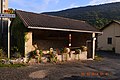 Armix Lavoir (Public Laundry)
 -
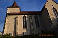 Armix Church


See also
Notes
- ^ At the beginning of the 21st century, the methods of identification have been modified by law No. 2002-276 of 27 February 2002 [1] , the so-called "law of local democracy" and in particular Title V "census operations" which allow, after a transitional period running from 2004 to 2008, the annual publication of the legal population of the different French administrative districts. For municipalities with a population greater than 10,000 inhabitants, a sample survey is conducted annually, the entire territory of these municipalities is taken into account at the end of the period of five years. The first "legal population" after 1999 under this new law came into force on 1 January 2009 and was based on the census of 2006.
- ^ In the census table and the graph, by convention in Wikipedia, and to allow a fair comparison between five yearly censuses, the principle has been retained for subsequent legal populations since 1999 displayed in the census table and the graph that shows populations for the years 2006, 2011, 2016, etc., as well as the latest legal population published by INSEE
References
External links
- Armix on the old IGN website Template:Fr icon
- Armix on Lion1906
- Armix on the 1750 Cassini Map
- Armix on the INSEE website Template:Fr icon
- INSEE Template:Fr icon