Azumino
Azumino
安曇野市 | |
|---|---|
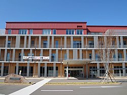
 Azumino City Hall | |
 Location of Azumino in Nagano | |
| Country | Japan |
| Region | Chūbu (Kōshin'etsu) |
| Prefecture | Nagano |
| Government | |
| • - Mayor | Munehiro Miyazawa |
| Area | |
• Total | 331.78 km2 (128.10 sq mi) |
| Population (October 2016) | |
• Total | 95,308 |
| • Density | 287/km2 (740/sq mi) |
| Time zone | UTC+9 (Japan Standard Time) |
| Symbols | |
| • Tree | Zelkova serrata |
| • Flower | Wasabi |
| Phone number | 0263-71-2000 |
| Address | 4932-26 Toyoshina, Azumino-shi, Nagano-ken 399-8205 |
| Website | www |

Azumino (安曇野市, Azumino-shi) is a city located in central Nagano Prefecture, in the Chūbu region of Japan. As of 1 October 2016[update], the city had an estimated population of 95,308 and a population density of 287 persons per km². Its total area was 331.78 square kilometres (128.10 sq mi).
Etymology of Azumino
Azumino is a combination of two words, "Azumi" and "no". "Azumi" comes from the Azumi people, who are said to have moved to the "no" (plain) in ancient times. The Azumi people originally lived in northern Kyushu, and were famed for their skills in fishing and navigation. "The Azumi people" can be translated as "the people who live on the sea." The reason why the seafaring people migrated to this mountainous region is a mystery.
Geography
Azumino is located into the Azumino Plateau on the northern end of the Matsumoto Basin, between two mountain ranges to the west and east. The range of mountains on the western border is known as the Northern Alps (Hida Mountains) and is popular among hikers all over Japan. To the south is the city of Matsumoto, Nagano prefecture's second largest city. To the north lies the city of Ōmachi, and north of Ōmachi is the village of Hakuba. Hakuba was the site of many of the ski events during the 1998 Winter Olympic Games. Mount Jōnen at 2,857 metres (9,373 ft) is the highest elevation in the city.
Surrounding municipalities
| Azumino city min/max temperature & rainfall | ||||||||||||||||||||||||||||||||||||||||||||||||||||||||||||
|---|---|---|---|---|---|---|---|---|---|---|---|---|---|---|---|---|---|---|---|---|---|---|---|---|---|---|---|---|---|---|---|---|---|---|---|---|---|---|---|---|---|---|---|---|---|---|---|---|---|---|---|---|---|---|---|---|---|---|---|---|
| Climate chart (explanation) | ||||||||||||||||||||||||||||||||||||||||||||||||||||||||||||
| ||||||||||||||||||||||||||||||||||||||||||||||||||||||||||||
| ||||||||||||||||||||||||||||||||||||||||||||||||||||||||||||
History
The area of present-day Azumino was part of ancient Shinano Province. The area was part of the holdings of Matsumoto Domain during the Edo period. The modern city of Azumino was established on October 1, 2005 by the merger of the town of Akashina (from Higashichikuma District), the towns of Hotaka and Toyoshina, and the villages of Horigane and Misato (all from Minamiazumi District).
Education
Azumino has ten public elementary schools and seven public middle schools. There are four public high schools operated by the Nagano Prefectural Board of Education.
Transportation
Railway
- JR East – Ōito Line
- Azusabashi - Hitoichiba - Nakagaya - Minami-Toyoshina - Toyoshina - Hakuyachō - Hotaka - Nagano - Azumi-Oiwake
- JR East – Shinonoi Line
Highway
- Nagano Expressway
- Japan National Route 19
- Japan National Route 143
- Japan National Route 147
- Japan National Route 403
Sister cities
Domestic
- Misato, Saitama, Saitama Prefecture
- Edogawa, Tokyo
- Musashino, Tokyo
- Manazuru, Kanagawa
- Sangō, Nara
- Higashi-ku, Fukuoka
International
 - Kramsach, Austria
 - Collierville, Tennessee, United states
Local attractions

- Azumino is home to the world's largest wasabi farm, Daio Wasabi Farm.[1]
- Jōkyō Gimin Memorial Museum
Notable people from Azumino
- Keikoku Fujimori (1835–1905), artist & educator
- Kigenji Iguchi (1870–1938), educator
- Kiyoshi Kiyosawa (1890–1945), journalist
- Kei Kumai (1930–2007), film director
- Kyūsaku Matsuzawa (1855–1887), people's rights activist
- Risaku Mutai (1890–1974), philosopher
- Rokuzan Ogiwara (1879–1910), sculptor
- Aizō Sōma (1870–1954), founded Nakamuraya
- Tada Kasuke (?–1687), executed farmer
- Setsuro Takahashi (1914–2007), lacquerware artist
- Etsujirō Uehara (1877–1962), political scientist & politician
- Yoshimi Usui (1905–1987), editor & writer
- Masaaki Iinuma (1912–1941), pilot & aviation pioneer
References
External links
![]() Media related to Azumino, Nagano at Wikimedia Commons
Media related to Azumino, Nagano at Wikimedia Commons


