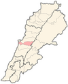
Baabda
Appearance
Baabda
بعبدا | |
|---|---|
City - Village | |
| Coordinates: 33°50′0″N 35°32′0″E / 33.83333°N 35.53333°E | |
| Country | |
| Governorate | Mount Lebanon Governorate |
| District | Baabda District |
| Time zone | UTC+2 (EET) |
| • Summer (DST) | UTC+3 (EEST) |
| Dialing code | +961 |
Baabda (Template:Lang-ar) is the capital city of Baabda District as well as the capital of Mount Lebanon Governorate, western Lebanon. Baabda was the capital city of the autonomous Ottoman Mount Lebanon. Baabda is known for the Ottoman Castle (the serail) and it has many embassies (Italian, Japanese, Jordanian, Polish, Ukrainian, Romanian, Indonesian, Spanish ... ), the Ministry of Defense and many important organization and administrative centres in Lebanon.
Baabda Palace, residence of the President of Lebanon is also located in Baabda.[1]
References
- ^ Tourism in Baabda Region. Lebanon.com. Retrieved on 2008-01-30.


