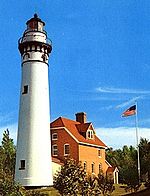
Baileys Harbor Light
This article includes a list of general references, but it lacks sufficient corresponding inline citations. (March 2014) |
 | |
 | |
| Location | Baileys Harbor, Wisconsin |
|---|---|
| Coordinates | 45°03′21″N 87°05′49″W / 45.05583°N 87.09694°W |
| Tower | |
| Constructed | 1852 |
| Construction | Stone |
| Light | |
| Deactivated | 1869 |
| Lens | Sixth order Fresnel lens |
The Baileys Harbor lighthouse is a lighthouse located near Baileys Harbor in Door County, Wisconsin.
Construction of Baileys Harbor Lighthouse began in 1852 and in 1853 David Ward became the first lighthouse keeper. It was the third lighthouse constructed in Door County after the lighthouses on Rock Island and Plum Island. An 1866 inspection declared the lighthouse was in "very defective condition" and in late fall of 1869 it closed. This coincided with the opening of the Baileys Harbor Range Lights and Cana Island Lighthouse in 1870. Today the island is privately owned and the lighthouse is in decay but still standing.[1]
Replaced by the Baileys Harbor Range Lights and the Cana Island Lighthouse in 1869. It is one of four lighthouses in the country to have retained its bird-cage lantern.
Notes
- ^ "Baileys Harbor Lighthouse". LighthouseFriends. Archived from the original on 2016-08-17. Retrieved 2016-06-04.
{{cite web}}: Unknown parameter|deadurl=ignored (|url-status=suggested) (help)
Further reading
- Havighurst, Walter (1943) The Long Ships Passing: The Story of the Great Lakes, Macmillan Publishers.
- Oleszewski, Wes, Great Lakes Lighthouses, American and Canadian: A Comprehensive Directory/Guide to Great Lakes Lighthouses, (Gwinn, Michigan: Avery Color Studios, Inc., 1998) ISBN 0-932212-98-0.
- Pepper, Terry. "Seeing the Light: Lighthouses on the western Great Lakes". Archived from the original on 2008-01-30.
{{cite web}}: Unknown parameter|deadurl=ignored (|url-status=suggested) (help) - Sapulski, Wayne S., (2001) Lighthouses of Lake Michigan: Past and Present (Paperback) (Fowlerville: Wilderness Adventure Books) ISBN 0-923568-47-6; ISBN 978-0-923568-47-4.
- Wright, Larry and Wright, Patricia, Great Lakes Lighthouses Encyclopedia Hardback (Erin: Boston Mills Press, 2006) ISBN 1-55046-399-3.
External links
- Seeing the light
- Lighthouse friends article
- Rowlett, Russ. "Lighthouses of the United States: Eastern Wisconsin". The Lighthouse Directory. University of North Carolina at Chapel Hill.
- "Historic Light Station Information and Photography: Wisconsin". United States Coast Guard Historian's Office. Archived from the original on 2017-05-01.

