
Broadway, Sydney

Broadway is a road in Sydney, in the state of New South Wales, Australia. The road constitutes the border between the suburbs of Ultimo (to the north) and Chippendale (to the south). Broadway is also an urban locality.
When travelling westward along Broadway the name changes into Parramatta Road at Victoria Park just after the junction with City Road. Broadway and Parramatta Road are part of the Great Western Highway. Broadway provides a link between the University of Sydney and the University of Technology, Sydney.
History
Broadway is historically important because it is one of the first roads built in the colony of New South Wales, in 1794. It had been called "George Street South" and then "George Street West". After being widened in 1906 when the Central Railway Station was built, George Street west of Railway Square, it became known as "The Broadway"[1]. This name was subsequently shortened to just "Broadway".
In the early nineteenth century, travel to Parramatta on Parramatta Rd attracted a toll and this was charged from the area now known as Railway Square. The toll gate was subsequently moved to the approximate junction of the present Broadway and Parramatta Rd.
Broadway was once home to the flagship building of department store chain Grace Brothers until 1995, operating there for 90 years. It was visited by Queen Elizabeth II during her 1954 visit to Australia. Today this site contains the Broadway Shopping Centre and the Hotel UniLodge Sydney.
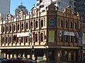
The Embassy Conference Centre is a historic building, built in the 1890s as the first branch of the Bank of New South Wales.
Broadway was a busy tram thoroughfare in the first half of the 20th century, until the line's closure in 1958[2].
-
 Embassy Conference Centre
 -
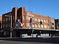 Bar Broadway
 -
 Agincourt Hotel


References
- ^ Widening the streets - City of Sydney website
- ^ D. Keenan: Tramways of Sydney. Transit Press 1979
External links
Template:Mapit-AUS-suburbscale
This Australian road or road transport-related article is a stub. You can help Wikipedia by expanding it. |
This article related to the geography of Sydney is a stub. You can help Wikipedia by expanding it. |