
Central Ostrobothnia
Central Ostrobothnia
Keski-Pohjanmaan maakunta Mellersta Österbottens landskap | |
|---|---|
 Coat of arms | |
 Central Ostrobothnia on a map of Finland | |
| Country | Finland |
| Historical province | Ostrobothnia |
| Area | |
| • Total | 5,706.39 km2 (2,203.25 sq mi) |
| Population (2013) | |
| • Total | 68,677 |
| • Density | 12/km2 (31/sq mi) |
| Time zone | UTC+2 (EET) |
| • Summer (DST) | UTC+3 (EEST) |
| ISO 3166 code | FI-07 |
| NUTS | 1A1 |
| Regional bird | Skylark (Alauda arvensis) |
| Regional fish | - |
| Regional flower | Bluebell (Harebell) |
| Website | keski-pohjanmaa.fi |
Central Ostrobothnia (Finnish: Keski-Pohjanmaa; Swedish: Mellersta Österbotten) is a region in Finland. It borders to the regions Ostrobothnia, Northern Ostrobothnia, Central Finland and Southern Ostrobothnia.
Historical provinces
For History, Geography and Culture see: Ostrobothnia
Regional council
Municipalities
The region of Central Ostrobothnia is made up of eight municipalities, of which two have city status (marked in bold).
|
Kaustinen sub-region: |
Kokkola sub-region:
|
Heraldry
Gallery
-
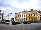 Kokkola Town Hall
 -
 Gulf of Bothnia in Lohtaja
 -
 Kaarlela Church in Kokkola originally built in late 15th century
 -
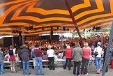 An annual folk music festival takes place in Kaustinen; the area used to have a strong tradition in folk music
 -
 Rural landscape in Kälviä
 -
 Veteli Church
 -
 A street view in Kokkola Old Town
 -
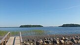 Lake Lestijärvi, Lestijärvi
 -
 Tankar lighthouse, Kokkola
 -
 Halsua Church
 -
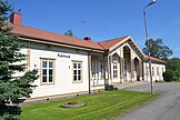 Kannus Railway Station
 -
 Kaustinen Church
 -
 Folk Arts Centre in Kaustinen
 -
 A former school building from 1696 in Kokkola; oldest preserved non-religious wooden building in Finland
 -
 A poor man statue at Kälviä Church


External links
Wikimedia Commons has media related to Central Ostrobothnia.
| Regions |  | |
|---|---|---|
| Former regions | ||
63°30′N 24°15′E / 63.500°N 24.250°E
This Western Finland location article is a stub. You can help Wikipedia by expanding it. |