Chagai District
This article needs additional citations for verification. (March 2012) |
ضِلع چاغى | |
|---|---|
| Chagai District ( Western Sanjrani Agency) | |
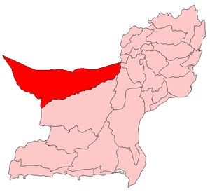
 Map of Balochistan with Chagai District highlighted in maroon | |
| Country | |
| Province | |
| Division | Quetta Division |
| Established | 1896 |
| Headquarters | Dalbandin |
| Government | |
| • District Chairman | Dawood Jan Notezai |
| Area | |
| • Total | 44,748 km2 (17,277 sq mi) |
| Time zone | UTC+5 (PST) |
| Website | http://chaghionline.com |
Chagai District Westen Sanjrani Agency (also Chaghi) (Balochi: ضِلع چاغى), is the largest district of Pakistan and is located on the north west corner of Balochistan, Pakistan.[1]
Administration
Chagai District is administratively subdivided into the following tehsils:[1]
See also
External links
Wikimedia Commons has media related to Chagai District.

