
Clearwater River (Alberta)
Clearwater is a river of southern Alberta, Canada. Situated entirely in the Canadian Rockies and the Rocky Mountain foothills of Alberta, it is a glacier fed upper reach tributary of the North Saskatchewan River. The upper reach of the Clearwater has become popular for equestrian travelers due to the natural setting along the river.
Course
When measuring from Trident Lake, the Clearwater River has a length of 203 kilometres (126 mi) and descends 350 metres (1,150 ft) to its end at Rocky Mountain House.
- The river begins in Banff National Park on the southern slope of Mount Wellington immediately into the Devon Lakes at Clearwater Pass.
- From the Devon Lakes it flows 11 kilometres (7 mi) and descends 400 metres (1,300 ft) to Clearwater Lake.
- About 2 kilometres (1.2 mi) after Clearwater Lake and 50 metres (160 ft) down the river hits Trident Lake, where it becomes navigable by canoe.
- After traveling 15 kilometres (9 mi) east and descending 120 metres (390 ft), the river exits Banff National Park.
- The river travels east 18 kilometres (11 mi) more and descends 150 metres (490 ft) before turning north and exiting the Ram Range in the Rocky Mountain Foothills.
- About 20 kilometres (12 mi) further along, the river turns east again and meets its first road around Idlewild Mountain.
- About 70 kilometres (43 mi) later, the river turns northwest.
- About 30 kilometres (19 mi) further, the river empties into the North Saskatchewan River.
Tributaries
|
|
Photo gallery
-
 Origin of Clearwater River from the Devon Lakes
 -
 Trident Lake along the Clearwater River
 -
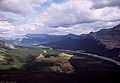 Clearwater River in the Canadian Rockies


Canadian Heritage Rivers System
There is another and more significant river that flows through Alberta, also called the Clearwater River, which originates in northern Saskatchewan. This Clearwater River,[notes 1][1] designated as part of the Canadian Heritage Rivers System, flows 187 kilometres (116 mi) from its headwaters in Lloyd Lake in northwestern Saskatchewan, through Saskatchewan and Alberta and joins the Athabasca River at Fort McMurray in the Regional Municipality of Wood Buffalo, eventually reaching the Mackenzie River and the Arctic Ocean.[1][2]"The lack of significant oil sands developments means that the Clearwater River can be used as a baseline river system to provide information on the variability and characteristics of natural systems."[2]
See also
References
- Wild Rivers. Alberta., by Canada. Wild Rivers Survey.
Notes
- ^ Clearwater river is named because of its "unspoiled, clear-water river in a pristine" isolated "wilderness setting of spectacular beauty."
References
- ^ a b "Clearwater River". Canadian Heritage Rivers System. Retrieved 11 June 2013.
- ^ a b "Clearwater River Hydrological Profile". Hydrology of the Athabasca Oil Sands Region. Regional Aquatics Monitoring Program (RAMP. Retrieved 11 June 2013.
External links
- Clearwater River Expedition - A journal log with photos describing a hike along the Clearwater River.
| Rivers |  | |
|---|---|---|
| Waterfalls | ||
| Lakes | ||
| Reservoirs | ||
| Glaciers | ||
| Other | ||