Solududhkunda Municipality
Solu Dudhkunda Municipality
दुधकुण्ड नगरपालिका | |
|---|---|
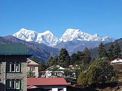
 View from Salleri | |
| Coordinates: 27°30′16″N 86°35′11″E / 27.50444°N 86.58639°E | |
| Country | Nepal |
| Province | Province No. 1 |
| District | Solukhumbu |
| Government | |
| • Mayor | Namgel Jangbu Sherpa (NC) |
| • Deputy Mayor | Kalpana Rai (NCP) |
| Area | |
| • Total | 528.09 km2 (203.90 sq mi) |
| • Rank | 2nd (Province No. 1) |
| Population (2011) | |
| • Total | 20,399 |
| • Density | 39/km2 (100/sq mi) |
| Website | official website |
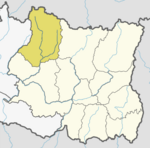
Dudhkunda Municipality (Nepali: दुधकुण्ड नगरपालिका) is the first municipality of Solukhumbu district. The village of Salleri, which is located within the municipality is the headquarter of Solukhumbu District in the Sagarmatha Zone of northern Nepal.[1] It was formed in 2014 by merging four VDCs: Salleri, Garma, Loding Tamakhani and Beni. It is divided into 9 wards. In 2011, Dudhkunda Municipality had a population of 11,247. At the time of the 1991 Nepal census it had a population of 5368 people living in 20,399 individual households.[2]
Media
To pomote local culture,Solu Dudhkunda Municipality has two Community radio Stations. one is Radio Dudhkoshi - 94.6 MHZ and Solu FM - 101.2 MHz.[citation needed]
Transportation
Most parts of Dudhkunda municipality have access to local roads. Phaplu Airport is located Phaplu in the northern part of the municipality.
References
- ^ Districts of Nepal - Staoids
- ^ "Nepal Census 2001". Nepal's Village Development Committees. Digital Himalaya. Retrieved 14 November 2008.


