
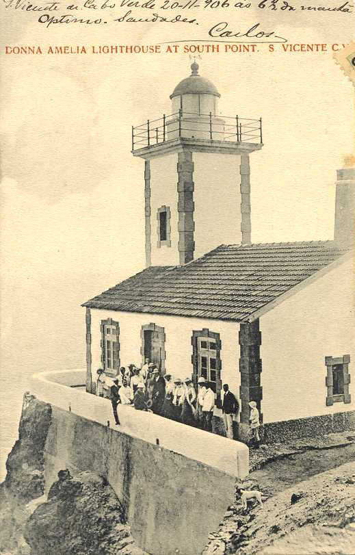
Dona Amélia Lighthouse
 Farol de Dona Amélia | |
 | |
| Location | near São Pedro São Vicente Cape Verde |
|---|---|
| Coordinates | 16°49′35.7″N 25°05′06.9″W / 16.826583°N 25.085250°W |
| Tower | |
| Constructed | 1894 |
| Construction | masonry tower |
| Height | 14 metres (46 ft) |
| Shape | square tower with balcony and lantern rising from one-story keeper's house |
| Markings | white tower |
| Light | |
| Focal height | 56 metres (184 ft) |
| Range | 17 nautical miles (31 km; 20 mi)[1] |
| Characteristic | Fl W 5s.[2] |
| Cape Verde no. | PT-2020 |
Farol de D. Amélia, also known as farol da ponta Machado (Ponta Machado Lighthouse) or farol de São Pedro is a lighthouse in the southwestern point of the island of São Vicente in northwestern Cape Verde approximately 3 km west of the village of São Pedro, it is in the westernmost part of the small hill range dominating the island's westernmost part. It is accessed via the resort named Foya Branca (which in the early 2010s added more villas) and continues by a pathway which contains stairways about 2 km long.
The lighthouse tower has a white square shape with a lantern and a gallery, 14 m high. The colour is white with pink.
The lighthouse was completed in 1894 in the heyday of ship traffic that almost all stopped at Porto Grande Bay and Mindelo, it continued until the Great Depression of 1930. Today it guides ships that are stopping or leaving Porto Grande Bay, domestic shipping and ferry and ships entering and leaving the archipelago.
About the lighthouse
- Characteristics: Light: 0.2s, occlusion: 4.8x, visible: 302°—172° (230°).
See also
References
- Russ Rowlett (June 9, 2010). "Ponta Machado (Farol Dona Amélia, São Pedro)". The Lighthouse Directory. UNC at Chapel Hill. Retrieved September 11, 2010.
- ^ List of Lights, Pub. 113: The West Coasts of Europe and Africa, the Mediterranean Sea, Black Sea and Azovskoye More (Sea of Azov) (PDF). List of Lights. United States National Geospatial-Intelligence Agency. 2015.
- ^ Rowlett, Russ. "Lighthouses of Cape Verde". The Lighthouse Directory. University of North Carolina at Chapel Hill. Retrieved January 12, 2016.
- ^ "D. Amélia". Lighthouses in Cape Verde. Direcção Geral da Marinha e Portos (DGMP). Archived from the original on May 31, 2010. Retrieved September 11, 2010.
{{cite web}}: Unknown parameter|deadurl=ignored (|url-status=suggested) (help)
External links
- Old post (Huelse)
- Photo at the DGMP (General Directory of the Sea and Ports) website Template:Pt icon
- 2006 photo at Mindelo Infos
The island of São Vicente | ||
|---|---|---|
| Communities and settlements |  | |
| Mountains | ||
| Streams | ||
| Other geographical features | ||
| Topics | ||
| Culture | ||
| |