Fort Dupont
Appearance
(Redirected from Fort Dupont, Washington, D.C.)
This article needs additional citations for verification. (December 2006) |
Fort Dupont | |
|---|---|
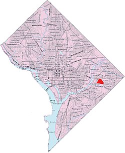
 Fort Dupont within the District of Columbia | |
| Country | United States |
| District | Washington, D.C. |
| Ward | Ward 7 |
| Government | |
| • Councilmember | Vincent C. Gray |

Fort Dupont is a residential neighborhood located in southeast Washington, D.C., east of the Anacostia River. It is bounded by East Capitol Street to the north, Fort Dupont Park to the south, Minnesota Avenue to the west, and Fort Chaplin Park to the east and northeast. Fort Dupont has a population of approximately 7,050.[1]
Fort Dupont is adjacent to Fort Dupont Park, the grounds of a Civil War-era fort that was constructed for the defense of Washington. Fort Dupont is a distinct neighborhood from the nearby Dupont Park, although both border the park and take their name from it.
See also
[edit]Footnotes
[edit]- ^ "Fort Dupont". niche.com. Retrieved June 7, 2021.
38°53′13″N 76°56′55″W / 38.887°N 76.9485°W
