Fort Ridgely State Park
This article lacks inline citations besides NRIS, a database which provides minimal and sometimes ambiguous information. (November 2013) |
Fort Ridgely State Park CCC/Rustic Style Historic Resources | |
 | |
| Nearest city | New Ulm, Minnesota |
|---|---|
| Coordinates | 44°27′3″N 94°43′36″W / 44.45083°N 94.72667°W |
| Area | 220 acres (89 ha) |
| Built | 1934 |
| Architect | Multiple |
| Architectural style | National Park Service rustic |
| MPS | Minnesota State Park CCC/WPA/Rustic Style MPS |
| NRHP reference No. | 89001668 [1] |
| Added to NRHP | October 25, 1989 |
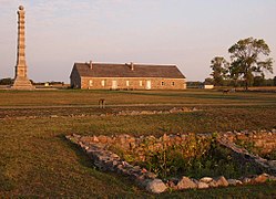
Fort Ridgely State Park is a state park of Minnesota, USA, on the Minnesota River south of Fairfax. It preserves Fort Ridgely, site of the Battle of Fort Ridgely during the Dakota War of 1862. It is the only Minnesota state park with a 9-hole golf course, which overlooks the Minnesota River and goes along Fort Ridgely Creek.
The Civilian Conservation Corps Rustic Style buildings within the state park, built between 1934 and 1936, are listed on the National Register of Historic Places.
References
External links
![]() Media related to Fort Ridgely State Park at Wikimedia Commons
Media related to Fort Ridgely State Park at Wikimedia Commons
Categories:
- 1911 establishments in Minnesota
- Battlefields of the wars between the United States and Native Americans
- Buildings and structures completed in 1936
- Civilian Conservation Corps in Minnesota
- Park buildings and structures on the National Register of Historic Places in Minnesota
- Protected areas established in 1911
- Protected areas of Nicollet County, Minnesota
- Protected areas of Renville County, Minnesota
- Rustic architecture in Minnesota
- State parks of Minnesota
- Historic districts on the National Register of Historic Places in Minnesota
- National Register of Historic Places in Renville County, Minnesota
- Minnesota Registered Historic Place stubs


