Frenchtown, Darke County, Ohio
Frenchtown, Ohio | |
|---|---|
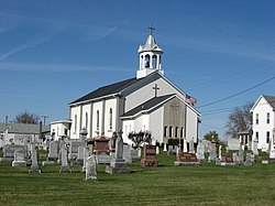
 Holy Family Church and Cemetery | |
 Location of Frenchtown, Ohio | |
| Coordinates: 40°14′47″N 84°31′26″W / 40.24639°N 84.52389°W | |
| Country | United States |
| State | Ohio |
| County | Darke |
| Township | Wayne |
| Elevation | 1,027 ft (313 m) |
| Time zone | UTC-5 (Eastern (EST)) |
| • Summer (DST) | UTC-4 (EDT) |
| GNIS feature ID | 1048761[1] |
Frenchtown is an unincorporated community in Wayne Township, Darke County, Ohio, United States. The community lies at the intersection of State Route 185 with Burns and Mangen Roads, approximately 2 miles (3.2 km) northwest of the village of Versailles.[2] Its elevation is 1,027 feet (313 m).[1]
The community was settled in the early nineteenth century primarily by people of French descent,[3] including many Alsatians and Lorrainers. These settlers long retained their French roots: into the late nineteenth century, the community was heavily Roman Catholic,[4] and their public inscriptions were made in the French language.[5] Although stores and a school were founded in Frenchtown soon after settlement, no post office was ever established there; residents' mail went to the Versailles post office.[3] Since the nineteenth century, the community has shrunk considerably; little now remains of Frenchtown except houses and a church complex. This church, Holy Family Catholic Church, is a community landmark: built in the 1860s, it is listed on the National Register of Historic Places.[5]
References
- ^ a b "Frenchtown, Ohio". Geographic Names Information System. United States Geological Survey, United States Department of the Interior.
- ^ DeLorme. Ohio Atlas & Gazetteer. 7th ed. Yarmouth: DeLorme, 2004, 54. ISBN 0-89933-281-1.
- ^ a b McIntosh, W.H. The History of Darke County, Ohio: Containing A History of the County; its Cities, Towns, etc.; General and Local Statistics; Portraits of Early Settlers and Prominent Men; History of the Northwest Territory; History of Ohio; Map of Darke County; Constitution of the United States, Miscellaneous Matters, etc., etc. Chicago: W.H. Beers, 1880, 416.
- ^ Hitchcock, A.B.C. "History of Shelby County, Ohio and Representative Citizens". Chicago: Richmond-Arnold, 1913, 367.
- ^ a b Brown, Mary Ann. Ohio Historic Inventory Nomination: Holy Family Catholic Church. Ohio Historical Society, February 1977.

