
Geryville, Pennsylvania

Geryville is a village located mainly in Milford Township, Bucks County but also in Upper Hanover Township, Montgomery County, in Pennsylvania. The first letter of the name is pronounced as a hard "g." It is located just north of Route 663 and is split between the East Greenville zip code of 18041 and the Pennsburg zip code of 18073. [1] Originally known as Aurora, the village received its name from the postmaster Jesse Gery in 1865. The Publick House on the corner of Sleepy Hollow Road and Geryville Pike played a prominent role in Fries's Rebellion of 1799. [2] It is drained via the Macoby Creek southward into the Perkiomen Creek and Schuylkill River.
Gallery
-
 Jamison Publick House, front.
 -
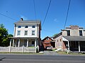 Geryville Pike in Geryville.
 -
 St Lukes Hospital.
 -
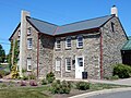 St Lukes Hospital, west wing.


External links
- Jamison Publick House [3]
Places adjacent to Geryville, Pennsylvania | ||||||||||||||||
|---|---|---|---|---|---|---|---|---|---|---|---|---|---|---|---|---|
| ||||||||||||||||


40°24′55″N 75°28′31″W / 40.41528°N 75.47528°W
This Bucks County, Pennsylvania state location article is a stub. You can help Wikipedia by expanding it. |
This Montgomery County, Pennsylvania state location article is a stub. You can help Wikipedia by expanding it. |