Grant Township, Indiana County, Pennsylvania
Grant Township, Pennsylvania | |
|---|---|
 Fields and hills along Burns Road | |
 Map of Indiana County, Pennsylvania Highlighting Grant Township | |
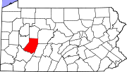
 Map of Pennsylvania highlighting Indiana County | |
| Country | United States |
| State | Pennsylvania |
| County | Indiana |
| Area | |
| • Total | 27.00 sq mi (69.94 km2) |
| • Land | 26.95 sq mi (69.79 km2) |
| • Water | 0.06 sq mi (0.15 km2) |
| Population (2010) | |
| • Total | 741 |
| • Estimate (2016)[2] | 703 |
| • Density | 26.09/sq mi (10.07/km2) |
| Time zone | UTC-5 (Eastern (EST)) |
| • Summer (DST) | UTC-4 (EDT) |
| FIPS code | 42-063-30416 |
Grant Township is a township in Indiana County, Pennsylvania, United States.
History
Grant Township was formed when the eastern half of the original Mahoning Township was divided in 1868 and named after President Ulysses S. Grant. The township includes the unincorporated communities of Bald Ridge, Decker's Point (previously called Colfax), Doty's Round Top, East Run, Kinter Hill, Nashville, and Rochester Mills (previously called Richmond).[3]
During the 1920s, the countryside of Grant Township was one of the few in Pennsylvania to have a woman, Grace Barr, appointed as a Rural Free Delivery carrier, delivering mail from the Rochester Mills Post Office.[4]
Geography
According to the United States Census Bureau, the township has a total area of 27.0 square miles (70 km2), all of it land.
Demographics
| Census | Pop. | Note | %± |
|---|---|---|---|
| 1870 | 999 | — | |
| 1880 | 1,318 | 31.9% | |
| 1890 | 1,350 | 2.4% | |
| 1900 | 1,285 | −4.8% | |
| 1910 | 1,095 | −14.8% | |
| 1920 | 975 | −11.0% | |
| 1930 | 837 | −14.2% | |
| 1940 | 929 | 11.0% | |
| 1950 | 863 | −7.1% | |
| 1960 | 694 | −19.6% | |
| 1970 | 637 | −8.2% | |
| 1980 | 770 | 20.9% | |
| 1990 | 729 | −5.3% | |
| 2000 | 696 | −4.5% | |
| 2010 | 741 | 6.5% | |
| 2016 (est.) | 703 | [2] | −5.1% |
| U.S. Decennial Census[5] | |||
The population was 741 at the 2010 census.[6]
As of the census[7] of 2000, there were 696 people, 279 households, and 195 families residing in the township. The population density was 25.8 people per square mile (10.0/km2). There were 347 housing units at an average density of 12.9/sq mi (5.0/km2). The racial makeup of the township was 99.57% White, 0.14% Native American, 0.14% Asian, and 0.14% from two or more races. Hispanic or Latino of any race were 0.29% of the population.
There were 279 households, out of which 30.5% had children under the age of 18 living with them, 58.8% were married couples living together, 6.8% had a female householder with no husband present, and 30.1% were non-families. 25.8% of all households were made up of individuals, and 15.1% had someone living alone who was 65 years of age or older. The average household size was 2.49 and the average family size was 3.01.
In the township the population was spread out, with 23.1% under the age of 18, 7.6% from 18 to 24, 28.0% from 25 to 44, 27.7% from 45 to 64, and 13.5% who were 65 years of age or older. The median age was 39 years. For every 100 females there were 110.3 males. For every 100 females age 18 and over, there were 105.8 males.
The median income for a household in the township was $27,500, and the median income for a family was $38,864. Males had a median income of $25,469 versus $16,346 for females. The per capita income for the township was $13,697. About 9.9% of families and 14.9% of the population were below the poverty line, including 23.3% of those under age 18 and 12.4% of those age 65 or over.
References
- ^ "2016 U.S. Gazetteer Files". United States Census Bureau. Retrieved Aug 14, 2017.
- ^ a b "Population and Housing Unit Estimates". Retrieved June 9, 2017.
- ^ "Resources for Grant Township". rootsweb.ancestry.com. Retrieved 2017-05-23.
- ^ "Miss Grace Barr of near Deckers Point...", Indiana Weekly Messenger, November 10, 1921, page five.
- ^ "Census of Population and Housing". Census.gov. Retrieved June 4, 2016.
- ^ "Geographic Identifiers: 2010 Census Summary File 1 (G001): Grant township, Indiana County, Pennsylvania". American Factfinder. U.S. Census Bureau. Archived from the original on February 13, 2020. Retrieved April 11, 2018.
- ^ "U.S. Census website". United States Census Bureau. Retrieved 2008-01-31.


